Lecture 1 - Fundamentals of
Meteorology
Knowledge of the current
state of the atmosphere is very important for the professional meteorologist.
Without knowledge of specific properties of the atmosphere, the meteorologist
has no idea what is going on. Some of the more common variables are
temperature, water vapor content (humidity), pressure, wind speed and
direction, and latitude and longitude. These variables must be monitored
contiually for use by the professional meteorologist to forecast the weather.
Temperature
Temperature is an arbitrary
measurement of heat, but not directly related to heat or energy. It represents
the average motion of the molecules in the air (ie. the higher the temperature,
the faster the molecules move). Temperature is measured using a thermometer.
The two main scales used are the Fahrenheit and Celsius scales. The Kelvin
scale (or "absolute" scale) is also used, but mainly for scientific
calculations. Zero on the Kelvin scale is the temperature at which random
molecular motion stops and a body would have no heat energy. This temperature
is called "absolute zero." Notice that the Kelvin scale does not use
degrees, only the Fahrenheit and Celsius scales. The following conversions
between scales are:
°C = (°F - 32) /
1.8
°F = (1.8 * °C) + 32
K = °C + 273.15
Degrees Fahrenheit, (developed in the early 1700's by G. Daniel Fahrenheit),
are used to record surface temperature measurements by meteorologists in the
United States. However, since most of the rest of the world uses degrees
Celsius (developed in the 18th Century) and upper air observations are recorded
in Celsius, it is important to be able to convert from units of degrees
Fahrenheit to degrees Celsius (and backwards). The only time you will probably
use Kelvin is in scientific formulas.
Humidity
Humidity is the amount of water vapor in the air. If the
air is very "sticky", then there is a high humidity, while if the air
is dry, then there is a low humidity. A good measure of how much water vapor is
in the air is the dew point temperature. As air is cooled, it becomes more
dense allowing it to "hold" less moisture. Eventually, the
temperature could drop to a point in which no more water can be held in the air
and therefore must condense (or "fall") out of the air. At this
point, the air is considered saturated.
The dew point temperature is a measure of the temperature at which water would
condense out of the air if it were cooled. The dew point temperature can then
be compared to the air temperature to get the relative humidity. When the air
temperature and the dew point temperature are close together, the relative
humidity is higher, than if the two temperatures were farther apart.
Pressure
Atmospheric pressure is defined as the force per unit area exerted
against a surface by the weight of the air above that surface. In the diagram
below, the pressure at point "X" increases as the weight of the air
above it increases. The same can be said about decreasing pressure, where the
pressure at point "X" decreases if the weight of the air above it
also decreases.
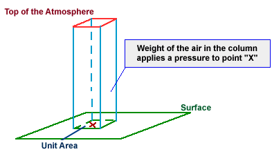
Thinking in terms of air molecules, if the number of air molecules above
a surface increases, there are more molecules to exert a force on that surface
and consequently, the pressure increases. The opposite is also true, where a
reduction in the number of air molecules above a surface will result in a
decrease in pressure. Atmospheric pressure is measured with an instrument
called a "barometer", which is why atmospheric pressure is also
referred to as barometric pressure. The barometer was invented in 1643 and
marked the beginning of true scientific study of the weather.
|
|
In aviation and television weather reports, pressure is
given in inches of mercury ("Hg), while meteorologists use millibars
(mb), the unit of pressure found on weather maps. |
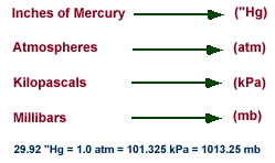
The conversions between the units of atmospheric pressure go as follows:
1
in Hg = 33.86 mb
1 Pa = 100 mb
1 kPa = 1000 Pa
As an example, consider a "unit
area" of 1 square inch, about the size of a quarter. At sea level, the
weight of the air above this unit area would (on average) weigh 14.7 pounds,
about the weight of an average bowling ball! That means pressure applied by
this air on the unit area would be 14.7 pounds per square inch. Meteorologists
use a metric unit for pressure called a millibar and the average pressure at
sea level is 1013.25 millibars.
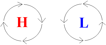
In the Northern Hemisphere (our hemisphere), a unique wind pattern is created
around high and low pressure centers by the Coriolis Force (you will learn this
one later). Around a high pressure center, the winds blow clockwise. Just the
opposite happens around a low a low pressure center - the winds blow
counter-clockwise.
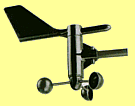
Wind
Wind has two different
measurements: speed and direction. We measure wind speed with an anemometer,
and wind direction is measured with a vane. Both of them can be seen in the
picture below.
Wind speed is measured in many units, such as miles per hour (mph), knots, and
meters per second (m/s). The most common measurement unit is the knot. The
conversions between the units go as follows:
1 knot = 1.15 mph
1 m/s = 2.24 mph
Wind direction is measured in degrees. The degrees in meteorology are different
than those used in mathematics. North is 0° (or 360°), east is 90°, south is
180°, and west is 270°. The direction tells us from where the wind is
blowing.
For example, a southwest wind means that the wind is blowing up from the
southwest.
Latitude and Longitude
Latitude and longitude lines
give us a way to divide up the Earth into a useable coordinate system. Every
point on Earth has both a longitude and a latitude.
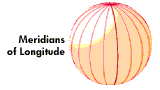
The lines running from the North Pole to the South Pole are called meridians.
Since the zero meridian (or Prime Meridian) runs through Greenwich, England,
the longitude of any place on Earth is simply how far east or west, in degrees,
it is from the prime meridian. North America is west of Great Britian and most
of the United States lies between latitude 75°W and 125°W longitude.
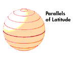
The lines running east and west paralleling the equator are called parallels of
latitude. The latitude of any place is how far north or south, in degrees, it
is from the equator. The latitude of the equator is 0°, whereas the latitude of
the North Pole is 90°N and that of the South Pole is 90°S. Most of the United
States is located between latitude 30°N and 50°N, a region commonly referred to
as the middle latitudes.
It is crucial that when labeling locations that you put W or E (on longitudes)
or N or S (on latitudes). 34.5° does not tell us much, but 34.5°N tells us a
lot more.
Note: Norman, OK is located at 35.22°N and 97.45°W.
Many portions of this material and images were taken from
the following source(s):
Univ.
of Illinois - WW2010
NWS Forecast Office in
Amarillo, Texas
Meteorology Today, Fifth Edition; C. Donald Ahrens
Latitude
and Longitude - A Brief Tutorial
Written by: Brad Illston