|
Weather
Briefing
|
Thursday's Noteworthies:
![]() Cold airmass in northern US
Cold airmass in northern US
![]() Pattern change to more zonal flow aloft over
US
Pattern change to more zonal flow aloft over
US
![]() Cyclone DORA
Cyclone DORA
UNC 79 Duke 73

![]()
Current weather:
Indian ocean satellite (tab) / Cyclone DORA (new window)
US water vapor imagery (Ramsdis WVapor loops)
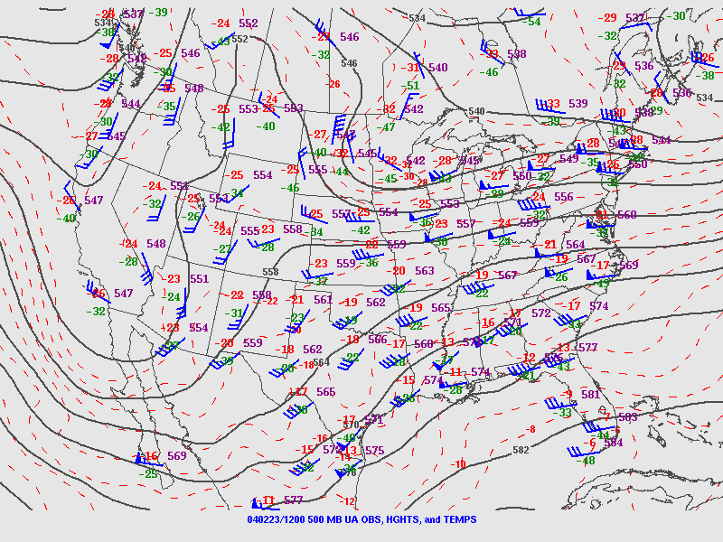
N.Hem. 500 hPa height/vorticity (IGES GFS )
Midwest vis. satellite image (NCAR RAP)
Up-state NY radar (Northeast Great Lakes), snowfall totals (NWS Buffalo)
Current US sfc temps: 18Z Hoot main page
Okla mesonet sfc map
Upper Analysis from RAP
U.S.
850mb 12Z
U.S.
700mb 12Z
U.S.
500mb 12Z
U.S.
250mb 12Z
Upper Analysis from SPC
U.S. 250mb
12Z
U.S.
500mb 12Z
U.S.
700mb 12Z
U.S.
850mb 12Z
Unisys US Visible (more Unisys satellite)
RAP US
Visible (more RAP
satellite)
Okla. Mesonet
OUN sounding (DDC more)
To the Future ...
NCEP GFS 78-hr
precip
ETA 72-hr
500mb height/wind
Forecast:
Norman, OK
| This Afternoon: | Persistent low
stratus. Wind NE 10-15 mph |
High 37 |
Average 51 |
| Tonight | Cloudy, chance of rain.
Winds E 5 mph. |
Low 30 |
Average 29 |
| Friday: | Clearing stratus,
developing cirrus. Winds SE 5 mph. |
High 45 |
|
| Friday night: | Mostly cloudy. Wind SE
5 mph. |
Low 28 |
|
| Saturday: | Mostly cloudy.
Slight chance rain. |
High 40 |
RAP US
Visible
Ramsdis WVapor
Upper Air Analysis
Other Current items
Current US temps (RUC
analysis)
RAP surface Pierre, SD
(Others)
00Z ht/temp 850mb
700mb
RAP surface AUS
Central TX
radar
Alaska 12Z
US Difax 15Z
RAP Central Plains
NRMN Meteogram
OK Mesonet
FWD sounding (Unisys ... more)
To the Future ...
RAP: RUC
15Z
Cold air in Canada .....
19Z Sunday surface
obs
TODAY
Radar mosaic
Water vapor loop
Oklahoma snow chances
UA Analysis: 300mb 500mb 850mb
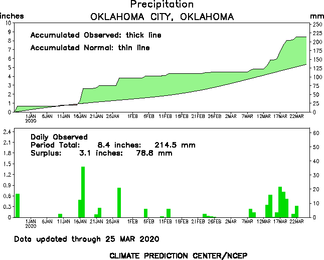
Rainfall totals: 48hr
Other Current Items
Current Satellite images
Ramsdis WVapor
RAP US Visible
Alaska IR
Current Surface Obs
Alaska 12Z
US Difax 15Z
RAP Central Plains
Upper Air Analysis
Other Current items
US RadarMosaic
NRMN Meteogram
OK Mesonet
To the Future ...
Forecast:
Norman, OK
| This Afternoon: | Cloudy with snow
showers. 1" accum. Winds N 20-25 mph. |
High 30 |
Average 48 |
| Tonight: | Chilly. Winds N 10-15
mph. |
Low 33 |
Average 26 |
| Tuesday: | Partly cloudy and
continued cool. Winds N 10 mph. |
High 40 |
|
| Tuesday night: | Pleasantly chilly. |
Low 23 |
|
| Wednesday: | Warming up slowly. |
High 50 |
|
| Trend thru next week: | Continued warm-up
end of the week; remains dry |
Average |
Kentucky vs Kansas Texas vs Syracuse
KENTUCKY vs TEXAS
TEXAS
![]()
Past:
| TEMPERATURES |
|
|
|
|
|
|
|
|
|
|
|
|
|
|
||
|
|
|
|
||
|
|
||||
|
|
|
|
Local Storm Reports | |
|
|
|
![]()
Present:
|
|
|
|
|
|
AIR |
|
|
|
|
|
|
|
|
|
|
|
||
|
|
|
||
|
|
|
|
|
|
|
|
||
|
|
|||
|
SENSING |
|
|
|
|
|
|
||
|
|
|
||
|
|
|
||
|
|
|
![]()
Future:
|
|
|
|
|
|
|
|
|
|
|
|
|
|
|
|
|
|
|
|
|
|
|
|
|
|
|
|
|
|
|
|
|
|
|
|
|
|
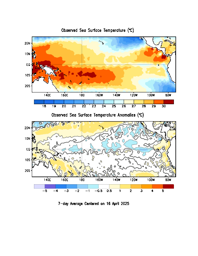
6-10 Day / 8-14 Day / Month / Season | |
|
|
|
|
|
| TPC |
|||
| Satellite / Track /
Winds |
|||
| Tropical
Analysis |
![]()
Forecast:
Norman, OK
| This Afternoon: | Clearing and drier,
winds light/variable |
|
|
| Tonight: | Seasonably cool. Winds
SE 5-10 mph. |
|
|
| Wednesday: | Partly cloudy and
warmer. Winds S 5-10 mph. |
|
|
| Wednesdaynight: | Remaining partly cloudy
and seasonable. |
|
|
| Thursday: | Clouding up; -TSRA psbl
late. Wind shift in afternoon. Toasty in Dallas ... 90F+ on the field? |
|
|
| Trend thru weekend: | Autumn chill in the air
- enjoy! |
Below Average
|