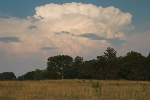
Cumulonimbus (Cb)
Personal Photo
Level: Extensive; base usually below 6,000 ft., top may be as high as 40,000 ft. or higher
Composition: Water and Ice
Typical Conditions: Moderately to highly unstable atmosphere capable of sustaining strong updrafts. Most common under warm, humid conditions, and/or ahead of a cold front or dryline. Cumulonimbus clouds typically produce heavy precipitation (including hail in some cases), lightning, and thunder. The cumulonimbus clouds with the highest tops and most severe weather are associated with supercell thunderstorms, which can produce tornadoes.
Appearance: Tall, bubbling mass that may be visible from a relatively long distance. If they are near or overhead, the base may appear very dark gray or nearly black. Often compared with a head of cauliflower. If the updraft inducing the cloud reaches the tropopause, an anvil may result - this is an extensive cloud layer with little vertical development at very high altitudes, and it often spreads out to cover a significantly larger area than the main structure of the cumulonimbus cloud.