Welcome to my cloud page! Scroll down to view different clouds and learn about how they form and what they mean.
There are four main classifications that can be given to clouds, which can be mixed and matched based on the cloud's composition.
Cirrus: Latin for "curl of hair", generally refers to wispy clouds.
Stratus: Latin for "layer", is given to clouds with a sheet-like appearance.
Cumulus: Latin for "heap", describes puffy clouds.
Nimbus: Latin for "violent rain", is simply given to any cloud with precipitation reaching the ground.
High Level Clouds
(20,000 to 60,000 feet)
High level clouds form in a very cold and dry environment, due to the high elevation. Because of this, high clouds are rather thin and composed almost exclusively of ice crystals. They ususally appear white, except for sunset when sunlight is reflected from the underside of the clouds, causing them to appear red, orange and yellow. There are three main types of high level clouds.
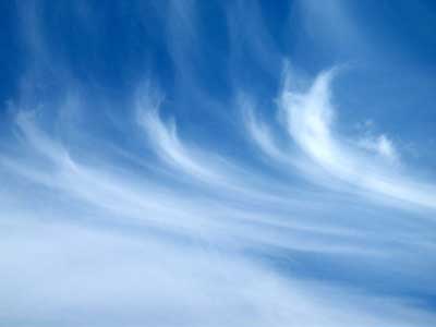
Cirrus Clouds
 Source: www.raggedcastle.com
Cirrus clouds are the most common type of high level clouds and appear thin and whispy. Cirrus clouds generally move from west to east, indicating the prevailing wind at their altitude. They usually indicate fair weather for the next day or two.
Cirrostratus Clouds
 Source: www.the airlinepilots.com
Cirrostratus clouds are thin and sheetlike in appearance, often covering the entire sky. In fact, they are thin enough to allow the sun and moon to shine through. Cirrostratus clouds often form ahead of an advancing thunderstorm, especially when they are thick. Therefore they are a good indicator of precipitation in the next 24 hours. Cirrostratus are often confused with Altostratus, so in order to tell the difference, look at the sun through the clouds. Cirrostratus clouds will cause a halo to form around the sun, while altostratus will simply show a dimly visible sun. The halo is caused by the ice crystals in the cloud refracting the sunlight.
Cirrocumulus Clouds
 Source: www.diracdelta.co.uk
Perhaps one of the more rare high level clouds are cirrocumulus clouds. These clouds appear as small, rounded white puffs occurring individually or in long rows, and often cover only a small portion of the sky. The reflected light of a setting sun turns the clouds a brilliant red or yellow, making cirrocumulus a very photogenic cloud. Because the small ripples of the clouds resemble the scales of a fish, a sky with cirrocumulus present is often calles a "mackerel sky."
Mid Level Clouds
(6,500 to 26,000 feet)
Mid level clouds form at a warmer altitude than the high level clouds, and are therefore composed mostly of water droplets. However, temperatures within the cloud could still drop low enough to allow ice crystals to form. There are two main types of mid level clouds.
Altostratus Clouds
 Source: eo.ucar.edu
Altostratus clouds appear as somewhat thin sheets and may have a grey or blue-grey hue. These often cover the majority if not all of the sky. Altostratus often form ahead of storms with widespread and continuous rainfall. Often confused with cirrostratus, altostratus can be distinguished by using the halo test. If the sun is visible through the clouds and does not have a halo, then the cloud is altostratus; if a halo is present, the cloud is cirrostratus.
Altocumulus Clouds
 Source: www.chitambo.com
Altocumulus clouds have a grey, puffy appearance and are sometimes rolled out in bands. These clouds are composed mostly of water droplets. If altocumulus is present on a warm and humid summer morning, it is a safe bet that thunderstorms will move in by late afternoon. Altocumulus are often confused with cirrocumulus, but a difference can be seen in the color of the cloud. Cirro cumulus are usually completely white, while altocumulus are white on top and grey on bottom.
Low Level CLouds
(Surface to 6,500 feet)
Low level clouds almost always consist of water droplets, but can contain ice particles and snow if the temperature is cold enough. Three main types of low level clouds exist.
Stratus Clouds
 Source: www.chitambo.com
Stratus clouds appear as a uniform greyish sheet, usually covering the entire sky. Often times these clouds resembles fog that has not yet reached the ground. Precipitation does not normally fall form this cloud, although there have been instances of light mist or drizzle associated with stratus. This cloud commonly forms over Atlantic and Pacific coastal waters in the summer.
Stratocumulus Clouds
 Source: www.notre-planete.info
Stratocumulus clouds appear as low, lumpy clouds occurring in rows or patches. Blue sky is often visible between these clouds, which are the spreading remains of cumulus clouds. Precipitation rarely falls from these clouds, but may occur in winter in the form of showers if the cloud elements develop vertically and the tops cool to about -5 degrees Celsius (23 F). Stratocumulus are often mistaken for altocumulus, but can be easily distinguished. If you hold your hand out at arm's length, you will find that altocumulus are roughly the size of your thumbnail, while stratocumulus are about the size of your fist.
Nimbostratus Clouds
 Source: www.gpc.edu
Dark grey, wet-looking layered clouds are nimbostratus. These clouds usually produce light to moderate precipitation, and hardly ever produce heavy or severe precipitation. The base of the nimbostratus is difficult to define, and its top may extend up to 10,000 feet (3 kilometers). Nimbostratus can be distinguished from altostratus because the sun is not visible through the former cloud.
Clouds with Vertical Development
Cumulus Clouds
 Source: www.scenicphoto.com
The ever puffy cumulus cloud takes on a variety of shapes, mostly that of cotton, sometimes of spilt milk. The base of these clouds could be as low as 3,300 feet on a humid day. The top of the cloud indicates the limit of rising air and is usually not very high. Cumulus with only slight vertical growth are called cumulus humilis (from Latin humilis meaning "of small size") and are often called "fair weather clouds" since they indicate pleasant weather. Smaller, more ragged cumulus are called cumulus fractus (from Latin frangere meaning "to break"). Cumulus will often develop throughout the day and grow into larger, more vertically developed clouds, called cumulus congestus (from Latin congerere meaning "to pile up").Showery precipitation at best will fall from these clouds.
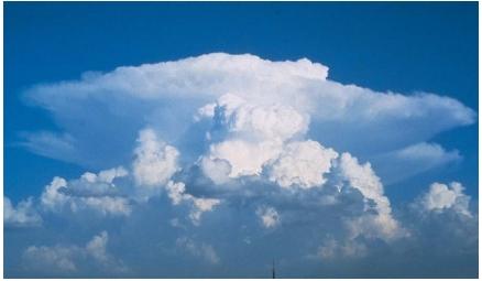
Cumulonimbus Clouds
 Source: www.scienceclarified.com
If conditions are favorable, the cumulus congestus will develop into a cumulonimbus cloud - your typical thunderstorm cloud. This cloud's base may be as low as 2,000 feet, while its top may shoot up to 39,000 feet! These clouds generally have a mushroom or anvil appearance and is composed of water droplets at the base and ice crystals with water droplets higher up. Only ice crystals compose the very top of this cloud. Dangerous weather can be associated with cumulonimbus, including gusty wind, heavy rain, lightning, hail, and sometimes tornadoes.
Unusual Clouds
There are several clouds that do not fit easily into the four main cloud classifications.
Lenticular Clouds
 Source: www.synthstuff.com
Lenticular clouds often form near mountainous areas. They occur when moist air crosses a mountain barrier and forms waves. The clouds form at the crest of these waves and will often form one on top of the other. Their peculiar shape has often resembled that of a UFO.
Mammatus Clouds
 Source: www.stupidexe.com
Mammatus are one of the few cloud types that form in sinking air. As the name suggests, mammatus resemble baglike sacs that hang from the underside of the cloud. Mamma typically form on the underside of cumulonimbus clouds, although they can form underneath other types, and usually indicate that a storm may be weakening. Mamma form when when sinking air is much cooler than the surrounding air and contains large amounts of liquid or frozen water. As the air sinks, it warms, but the warming is haltered because of the heat taken from the air to evaporate the liquid or melt the ice. If the sinking air remains saturated and cooler than the surrounding air, the sinking air will continue below the cloud base, forming the mammatus.
Funnel Clouds
 Source: leekottner.com
A funnel cloud, simply put, is a tornado that has not yet reached the ground. It is a violently spinning column that extends down from the updraft of a supercell thunderstorm. To distinguish a funnel cloud from a low hanging cloud, look for rotation around a single vertical line. Seek shelter immediately if you see this cloud!
Cloud Strife
 Source: www.ffinsider.net
If you see this cloud coming, I'd suggest running away very fast...
Back to Main