CLOUDS!!!!
Your ultimate guide to cloud nomenclature, development, recognition, and function!!

Low-Level Clouds
Mid-Level Clouds
High-Level Clouds
Vertical Development Clouds
Height of Cloud Base
Below 2000 m
Between 2000m and 7000m
Above 7000m
All Levels
Cloud Types
Nimbostratus
Stratocumulus
Stratus
Altocumulus
Altostratus
Cirrus
Cirrocumulus
Cirrostratus
Cumulus
Cumulonimbus

Cloud Descriptions*
Low-Level Clouds
Nimbostratus-(Ns)- Dark gray, "wet"-looking cloudy layer that is usually related to continuous rain and snow. The amount of precipitation with these clouds is usually light to moderate. The base of these clouds is usually almost too low to identify, but its top can be over 3 kilometers. Visibility with these clouds is usually very low because if the air becomes saturated, fog will form below the cloud base. These clouds move really quickly with the wind and they form shreds called stratus fractus or scuds.


Source: www.uwsp.edu/geo/faculty/ritter/images/atmosphere/clouds/nimbostratus_NOAA_wea02042.jpg


Stratocumulus-(Sc)- Low, lumpy clouds that appears in rows, patches, or rounded masses with the blue sky visible between the individual clouds. The usually appear near sunset as the remains of a larger cumulus cloud. Sometimes the sun with shine through the breaks in these clouds producing crepsular rays, bands of light that appear to reach the ground. The color of these clouds ranges from light to dark grey. Precipitation rarely forms from these clouds unless they form vertically into larger clouds with tops cooler than -5 degrees Celcius.


Source: www.capetownskies.com/7981/13_cumulus_gapsb.jpg


Stratus-(St)- Uniform grayish clouds that usually cover the entire sky. They resemble a fog that does not reach all the way down to the ground. These clouds usually result when a fog lifts. Precipitation doesn't normally fall from this type of cloud, but is sometimes associated with light mist or drizzle. The sun often appears watery through these clouds.


Source: mal.sbo.hamptom.k12.va.us/mangus_images/stratus.JPG


Mid-Level Clouds
Altocumulus-(Ac)- Middle level clouds that are made up of water droplets and aren't any thicker than 1 kilometer thick. They appear as gray, puffy masses, sometimes rolled out in parallel bands or waves. One part of the cloud is usually darker than the other. These clouds look like "little castles," or castellanus, in the sky. The appearance of these clouds on warm, humid summer mornings usually means thunderstorms by late afternoon.


Source: meteonew.free.fr/Images/photos/altocumulus/altocumulus2_grand.jpg


Altostratus-(As)- Gray or blue-gray cloud made up of ice crystals or water droplets. These clouds usually cover the entire sky across an area of several hundred kilometers. In thinner parts of these clouds, the sun (or moon) may be dimly visible as a round disk. This appearance is referred to as a "watery sun." These clouds often form ahead of storms having wipespread and continuous precipitation. When precipitation falls from these clouds, the base lowers. When this happens, the cloud is classified as nimbostratus.


Source: mrkay.astronomie.cz/pic/as01.jpg


High-Level Clouds
Cirrus-(Ci)- These are the most common of any high clouds. They are thin and wispy blown by high winds into long streamers called mares' tails. They can look like white, feathery patch with a faint wisp of a tail at one end. They usually move across the sky from west to east, indicating the prevailing winds at their height, and generally indicated pleasant weather.


Source: www.alanbauer.com/images/Weather/Cirrus%20clouds+Horz.jpg


Cirrocumulus-(Cc)- Small, rounded, white puffy clouds that appear both individually and in rows. When they appear in rows they have a rippling appearance. These clouds rarely ever cover more than a small portion of the sky. These clouds reflect the red or yellow light of the sun making a very beautiful sunset. The ripples of these clouds look llike the scales of a fish, so the term "mackerel sky" decribes a sky full of these clouds.


Source: www.zsmorava.cz/mrkay/cirrocumulus.jpg


Cirrostratus-(Cs)- Thin, sheetlike, high clouds that often cover the entire sky. These clouds are so thin that the sun and moon can be seen clearly through them. The ice crystals in these clouds refract the light passing through them and produce a sort halo, or a ring of light around the sun or moon which is the only indication that it is there. When these clouds form a thick layer, they give the sky a very white appearance and usually form in front of advancing storms. If these clouds are followed by middle-type clouds, they can be used to predict rain or snow within 12 to 24 hours.


Source: www.top-wetter.de/lexikon/c/cirrostratus.jpg


Vertical Development Clouds
Cumulus-(Cu)- This type of cloud can type a variety of shapes and is most commonly referred to a piece of cotton with sharp outlines and a flat base. This base appears anywhere from white to light gray, and on humid days, may only be about 1000m above the ground and about a kilometer wide. The dome shaped top of the cloud is the limit of the rising air and is usually not very high. These clouds are usually detached from other clouds. Cumulus clouds with only slight vertical development are called cumulus humilis, and are associated with fair weather conditions, so they are referred to as "fair weather cumulus."Ragged-edge cumulus clouds that are smaller than the cumulus humilis and scatter across the sky are called cumulus fractus. These clouds are generally harmless, and form in the mornings and by the afternoon they are more vertically developed and a great deal larger. When this cloud has vertically developed into the shape of a cauliflower, it is known as a cumulus congestus, or towering cumulus (Tcu). More often than not, these clouds form as a single large cloud, but sometimes they grow into eachother, forming the towering cloud.


Source: www.cbox.cz/tomas_psika/cumulus/bwo13327.jpg


Cumulonimbus-(Cb)- When a cumulus cloud continues to grow vertically, it becomes a large cumulonimbus cloud, which is more commonly known as a thunderstorm cloud. The base of these clouds are usually dark and no more than 600m above the earth's surface, while the top may be higher than 12,000m higher. These can develop either individually or as a line, or "wall" of clouds. Very large amounts of energy are released by the condensation of water within the cloud, which results in the development of violent updrafts and downdrafts which can exceed 70 knots. The lower part of the cloud is made up of water droplets, while the top of the cloud is made up of ice crystals. The winds at the higher altitudes can reshape the cloud into a very large, flattened anvil called a cumulonimbus incus. Lightning, thunder, and even tornadoes are associated with these clouds.


Source:www.top-wetter.de/spezial/ueber_den_wolken/24gr_cumulonimbus.jpg


Cloud Nomenclature*
Term
Latin Root
and Meaning
Description
Picture
Lenticularis
lens, lenticula
lentil
Clouds have the shape of a lens or an almond, elongated and with well defined outlines. This term applies to mostly cirrocumulus, altocumulus, and stratocumulus clouds.


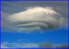
Source:www.sternwarte-singen.de/bilder/lenticularis_wolke_190805_ha222vss.jpg
Fractus
Frangere
to break or fracture
Clouds have a ragged or torn appearance. This term applies to only stratus and cumulus clouds.


Source: www.dmi.dk/dmi/fractus.jpg
Humilis
humilis
of small size
Cumulus clouds with flattened bases and slight vertical growth.


Source: www.weatherpictures.nl/pictures/humilis079801.jpg
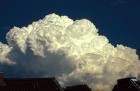
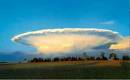
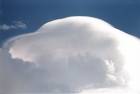
Congestus
congerere
to bring together
to pile up
Cumulus clouds of great vertical extent that looks like a head of cauliflower.

Source: www.top-wetter.de/lexikon/c/congestus.jpg
Calvus
calbus
bald
Cumulonimbus clouds with at some of the upper part beginning to lose its outline.

Source: www.wildlandschool.net/curric/quiz/clouds/Comulonimbus%20with%20Pileus.jpg
Capillatus
capillus
hair
having hair
Cumulonimbus characterized by the presence of cirriform clouds with fibrous or striated structure in the upper portion of the cloud.

Source: members.lycos.nl/wolkenatlas/Cb%20capillatus%20incus.jpg
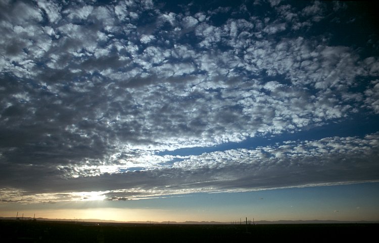
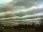
Undulatus
unda
wave
having waves
Clouds in patches, sheets, or layers showing undulations.

Source: www.wral.com/2006/0125/6433563.jpg
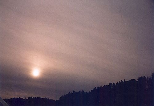
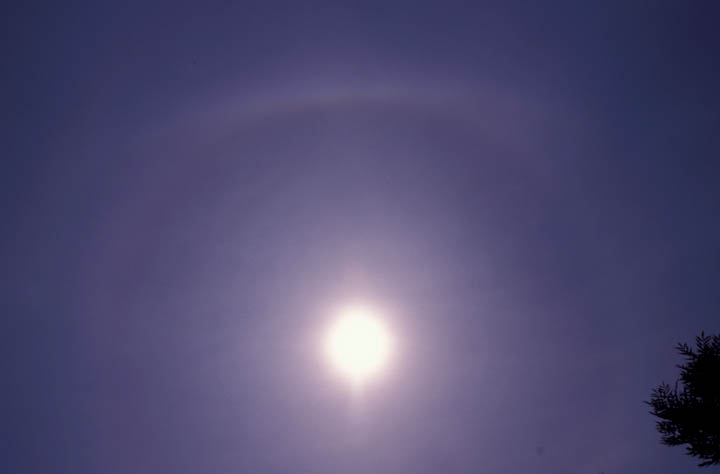
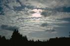
Translucidus
translucere
to shine through
transparent
Clouds that cover a large portion of the sky that are translucent to reveal the sun or the moon.

Source: www.ems.psu.edu/~lno/Meteo437/clouds/ScstundCufra.jpg
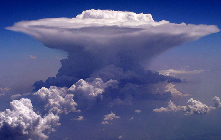
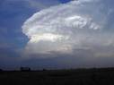
Incus
incus
anvil
A smooth cirroform mass of a cloud in the upper part of a cumulonimbus that is anvil-shapped.

Source: www.auf.asn.au/metimages/milthorpeincus.jpg
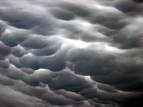
Mammatus
mamma
mammary
Baglike clouds that hang like the udder of a cow on the underside of the cloud. This can occur with cirrus, altocumulus, altostratus, stratocumulus, and cumulonimbus.

Source: springcreekforest.org/images/Mammatus-Clouds2.jpg
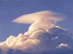
Pileus
pilus
cap
A cloud in the form of a cap or hood above or attached to the upper part of the cumuliform cloud, mostly during the development stage.

Source: www.yorku.ca/esse/atmos/image/pileus-cloud2.jpg
Castellanus
castellum
a castle
Clouds that show vertical development and produce towerlike extensions in the shape of small castles.

Source: www.meteo-julianadorp.nl/wolkenatlas/altocumulus/ac_castell002.jpg

*All cloud decriptions and cloud nomenclature taken from Meteorology Today, 8th Edition, C. Donald Ahrens, 2007.