Last Updated: 29 July, 2000
Note: Due to space limitations, most of these pictures and thumbnails are on another server. If the images don't appear or are slow to appear, there may be a problem at the other server. Please try again later.
© 2000 Kevin Scharfenberg |
umass1.jpg
- 17K 
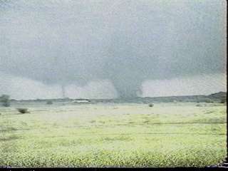
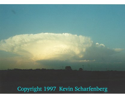
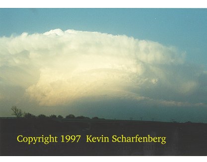
The University of Massachusetts 3mm radar studies the Miami, TX supercell. During the spring of 2000, I participated in a tornado research project led by Dr. Howie Bluestein of the University of Oklahoma and Dr. Andy Pazmany of the University of Massachusetts. My duties included navigation and coordination with the Doppler on Wheels group and nowcasters. |
© 2000 Kevin Scharfenberg |
umass2.jpg
- 16K The University of Massachussets 3mm radar studies the Miami, TX supercell. Although the supercell did not produce a tornado, the storm's structure indicated large scale rotation was present. |
© 2000 Kevin Scharfenberg |
miami1.jpg
- 16K The supercell as viewed immeadiately north-northeast of the updraft. The visual "vault" is clearly evident in the upper-left part of the image. At this time, small hail was falling at our location. |
© 2000 Kevin Scharfenberg |
miami2.jpg
- 14K The supercell during its early stages, about 5:45 pm CDT. The storm began as high based and disorganized, but as more moisture was pulled toward the updraft, the supercell "broke through" and the base rapidly descended and became more laminar. This transition took place in less than 5 minutes. |
© 1999 Kevin Scharfenberg |
denalinp.jpg
- 111K Scenery at Denali National Park, Alaska. This photograph was taken along the only road in this huge national park. The park was originally named for President McKinley, but was recently changed back to the Native American name for the mountain, "Denali". Many Alaskans are in favor of also changing the name of the mountain itself back to Denali. |
© 1999 Kevin Scharfenberg |
helens.jpg
- 115K Scenery near Mount Saint Helens, Washington. Mt. St. Helens erupted in 1980, and is still considered active today. This photograph was taken from the visitor's center. |
© 1999 Kevin Scharfenberg |
hubbard.jpg
- 112K Hubbard Glacier, Alaska. This photograph was taken from the deck of the M.S. Statendam during my cruise of the Inside Passage. |
© 1999 Kevin Scharfenberg |
hubbard2.jpg
- 146K Scenery near Hubbard Glacier, Alaska. Small chunks of ice from the glacier can be seen floating in the foreground. Although the ship is close to the shore, the water is quite deep. |
© 1999 Kevin Scharfenberg |
juneau.jpg
- 157K Mendenhall Glacier near Juneau, Alaska. The glacier and Mendenhall lake feed the Mendenhall river, which is a fun float trip. Juneau is only accessible by boat or plane. With temperatures near 80 ° F, this was one of the warmest days of the year for Juneau residents. |
© 1999 Kevin Scharfenberg |
rainier.jpg
- 134K Mount Rainier, Washington and a small lenticular cloud. Although this picture was taken during mid July, the incredible snow pack from the winter of 1998-99 is still quite evident. More than a foot of snow was still on the ground at Paradise lodge. |
© 1999 Kevin Scharfenberg |
rainier1.jpg
- 182K Scenery near Mount Rainier, Washington. My visit was during a warm, sunny weekend in Mid July, meaning many local residents flocked to the park for a weekend outing. |
© 1999 Kevin Scharfenberg |
rainier2.jpg
- 177K Scenery near Mount Rainier, Washington. Although the park was quite crowded, the scenery made the trip quite worthwhile! |
© 1999 Kevin Scharfenberg |
rainier3.jpg
- 102K Mount Rainier, Washington. This picture was one of many taken from one of the overlooks surrounding the mountain, but ranks as my favorite. |
© 1999 Kevin Scharfenberg |
sunset.jpg
- 97K A sunset on the Inside Passage between Ketchikan and Juneau, Alaska. This picture was taken from the deck of the M.S. Statendam at about midnight local time. |
© 1999 Kevin Scharfenberg |
valdez.jpg
- 84K Bridal Veil Falls near Valdez, Alaska. This photograph was taken in Keystone Canyon, along the Richardson highway between Valdez and Thompson Pass. Thompson Pass receives more than 300 inches of snow each year, with a record of more than 900 inches recorded in one season. |
© 1999 Kevin Scharfenberg |
laverty.jpg
- 68K This is a capture from our video of the May 3, 1999 tornado outbreak. In this image, two separate tornadoes are ongoing near Laverty, OK. |
© 1997 Kevin Scharfenberg |
mar27c.jpg
- 17K This is a beautiful supercell on March 27, 1997 between Oklahoma City and Tulsa, Oklahoma. |
© 1997 Kevin Scharfenberg |
mar27e.jpg
- 17K This is a beautiful supercell on March 27, 1997 between Oklahoma City and Tulsa, Oklahoma. |
© 1997 Kevin Scharfenberg |
mar27f.jpg
- 17K This is a beautiful supercell on March 27, 1997 between Oklahoma City and Tulsa, Oklahoma. |