 (apologies
for the pathetic drawing but you get the idea!)
(apologies
for the pathetic drawing but you get the idea!)Meteorology 1111, Fall 2002
Due: 10/14 at beginning of class
1 pt for each possible answer
Part 1
1. (Yes or No) Are isolines and isopleths the same thing?
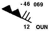
2. Does the following station plot give you the dewpoint or the dewpoint depression?
(apologies
for the pathetic drawing but you get the idea!)
3. What is this station's dewpoint?
4. If this station plot is taken from a 250 mb chart, what is the geopotential height at that level (in meters)?
Part 2--Use the 500mb map provided to answer the following:
Omaha, Nebraska (OAX)
Temperature: ___________°C
Dew Point Depression: ___________°C
Dew Point: ___________°C
Wind Speed:__________ (in knots)
Wind Speed:____________ ( in mph) (remember, 1.15 mph = 1 kt)
Wind Direction: ____________(in degrees) = _____________ (cardinal--meaning
use N,S,E,&W to describe)
Geopotential Height:_______________(in meters)
Geopotential Height:________________(in feet) (there are 3.28 feet in a meter)
Pressure = __________mb (tricky one)
Key West, Florida (EYW)
Temperature: ___________°C
Dew Point: ___________°C
Geopotential Height:_______________(in meters)
Geopotential Height:_______________(in kilometers) (1000m = 1km)
5. If we accept that this is a typical 500mb map, what generally happens to temperatures as you move poleward at 500mb?
6. What happens to geopotential heights as you move poleward?
FYI: The correspondence between these two observations is no coincidence. Cold air is more dense than warm and it takes up less space, so you won't have to fly as high to get to the 500mb level in colder air as you would in warmer air.