 scale, especially with precipitation, are still difficult. or meso-
 scale disturbances, such as cloud clusters along the Baiu front
in early summer, rain systems associated with typhoons and cyclones, snow
storms in the winter season, and so on.
scale disturbances, such as cloud clusters along the Baiu front
in early summer, rain systems associated with typhoons and cyclones, snow
storms in the winter season, and so on.
These disturbances are embedded in large-scale disturbances and the
hierarchical structures are commonly observed. The large-scale disturbances
are well forecasted by operational regional prediction models. However,
forecast of disturbances smaller than meso- scale, especially with precipitation, are still difficult.
Our group (Forecast Research Department, Meteorological Research Institute (MRI), Japan Meteorological Agency (JMA)) studies mesoscale diturbances and weather phenomena theoretically, analytically, numerically and statistically. Here I would like to introduce our recent works related to numerical studies of storms with heavy rainfall/snowfall. Our main activities are development of numerical techniques and models (hydrostatic and non-hydrostatic versions), and validation/comparison of numerical simulations of observed/analysed mesoscale events.
 -vertical coordinate, which had been in operation at JMA until February 1996. It is now being used as a research
model mainly to investigate the mechanisms of mesoscale disturbances by
reducing the horizontal resolution to 10-20 km, which was 30 km
in operational model.
-vertical coordinate, which had been in operation at JMA until February 1996. It is now being used as a research
model mainly to investigate the mechanisms of mesoscale disturbances by
reducing the horizontal resolution to 10-20 km, which was 30 km
in operational model.Extratropical cyclones, which pass along the southern coast of the Japan Islands in the winter season, sometimes bring strong wind and heavy snowfall around Tokyo. Takano(1996) applied the JSM to the rapidly developing cyclone on 12 February 1994. The model simulated development of the cyclone successfully. He showed that snowfall was intensified by the frontogenesis on the eastern and northern sides of the cyclone.
The correction of positional errors of precipitation between the JSM forecast fields and the observations is an important problem for assimilation. Aonashi and Shibata (1996) developed an assimilation method, which modifies the relative humidity (RH) and divergence of background data provided by the JSM, and evaluated the impact of assimilating precipitable water content (PWC) and rain flag data derived from SSM/I data. This method reduces the positional errors of the precipitation forecasts by the JSM. The assimilation of PWC is found to be effective in eliminating model precipitation in the observed rain-free areas, while that of rain flag data is found to be effective in generating model precipitation in the observed precipitation areas.
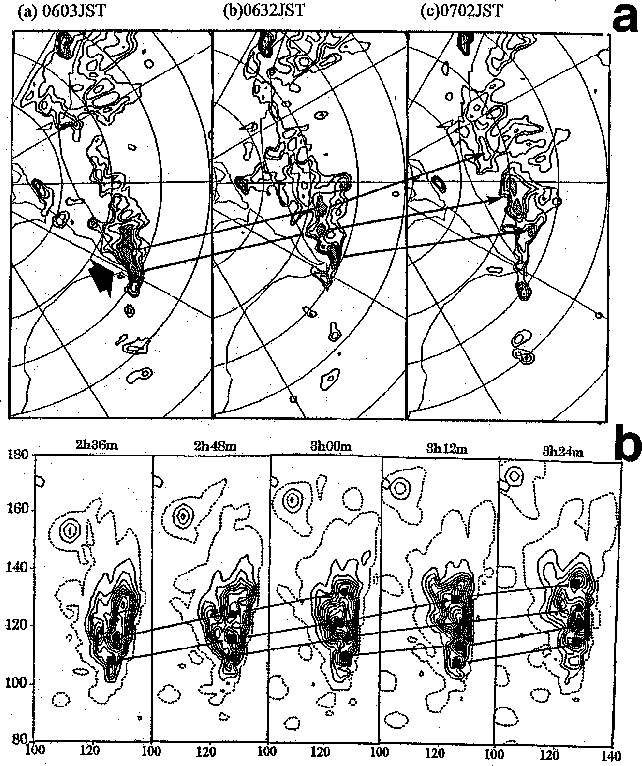
Kato(1996) studied a torrential rainfall case, which occurred over the
southern Kyushu Island on 1 August 1993. A quasi-stationary rainband was
observed for a long time along the Baiu front, where highly humid air was
advected from the southwest and the temperature contrast was large. Under such
an environmental condition, a quasi-stationary rainband aligned along the
front was successfully simulated. First, shallow convective rolls parallel to
the middle westerly winds with a space interval of about 25 km appear
(Fig. 1), and then the low pressure is induced in the lower layer as they are
developed into severe convective systems, forming a convergence line. The
low-level jet (LLJ) around the rainband was also simulated. The LLJ was produced
by the lower-level low pressure induced by the active convection in the southern
front of the rainband.
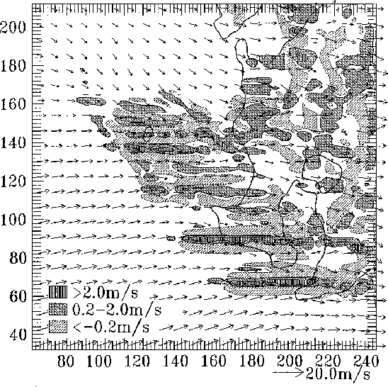
Seko et al. (1996) studied another quasi-stationary rainband, which
persisted for more than 10 hours over the Kanto area when Typhoon 9426 (Orchid)
approached the Japan Islands. The back building features of the rainband, such
as carrot-shaped pattern, and multicellular structure, were successfully
simulated (Fig. 2). They also tried several sensitivity experiments and showed
that the horizontal temperature gradient and the vertical wind shear play
important roles in organizing the quasi-stationary rainband.
To increase case studies, we participated or are going to participate in special observations. In "Tsukuba Area Precipitation Studies", we observed mesoscale precipitation phenomena over the Kanto area for more than three years by ourselves, using upper-air soundings and several remote measurement systems such as Doppler radars, with cooperation of other research institutes and universities. The GPS (Global Positioning System) meteorology will start, in which operational data of PWC with the horizontal resolution of about 20 km are applicable to meso-analyses and initialization of mesoscale prediction models. The "East China Sea - Baiu Project" (ECS-Baiu) is planned to observe cloud clusters along the Baiu front in 1998 and 1999, in which JMA observation vessels, air-borne Doppler radar, and remote-sensing measuring systems on surface will be operated over and around the East China Sea.
In this article, I have introduced numerical works in our group alone. The MRI is actively promoting widespread observational and numerical studies of other mesoscale disturbances such as local fronts, local winds (e.g., Saito 1994), cloud physics and so on.
Aonashi, K. and A. Shibata, 1996: The impact of assimilating SSM/I precipitable water and rain flag data on humidity analysis and short-term precipitation forecasts. J. Meteor. Soc. Japan, 74, 77-99.
Ikawa, M. and K. Saito, 1991: Description of a nonhydrostatic model developed at the Forecast Research Department of the MRI. Tech. Rep. of the MRI, 28, 238 pp.
Kato, T., 1995: A box-Lagrangian rain drop-scheme. J. Meteor. Soc. Japan, 73, 241-245.
Kato, T., 1996: Numerical simulation of line-shaped torrential rainband occurred in the southern Kyushu, Japan on 1 August 1993. Preprints, 7th Conf. on Mesoscale Processes, Reading, UK, Amer. Meteor. Soc., 437-438.
Saito, K., 1994: A numerical study of the local downslope wind "Yamaji-kaze" in Japan. Part 3: Numerical simulation of the 27th September 1991 windstorm with a non-hydrostatic multi-nested model. J. Meteor. Soc. Japan, 72, 301-329.
Saito, K., 1996: Semi-implicit fully compressible version of the MRI mesoscale nonhydrostatic model. -Forecast experiment of the 6 August 1993 Kagoshima torrential rain- (Submitted to J. Meteor. Soc. Japan.)
Seko H., T. Kato, K. Saito, M. Yoshizaki, K. Kusunoki, H. Okamura and Members of Tsukuba Area Precipitation Studies, 1996: Analytical and numerical studies of a quasi-stationary precipitation band observed over the Kanto area associated with Typhoon 9426 (Orchid). (Submitted to J. Meteor. Soc. Japan.)
Takano, I., 1996: A case study of an extratropical cyclone over the Kuroshio current - analysis and simulation. Proc. Autumm Meeting of Japan Meteorological Society (1996), B203.
Yoshizaki, M. and H. Seko, 1994: A retrieval of thermodynamic and microphysical variables by using wind data in simulated multi-cellular convective storms. J. Meteor. Soc. Japan, 72, 31-42.