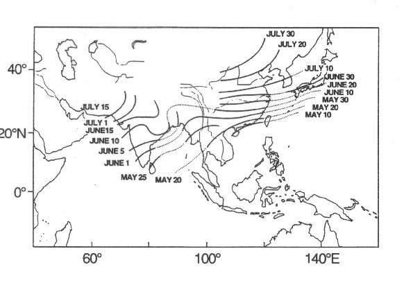
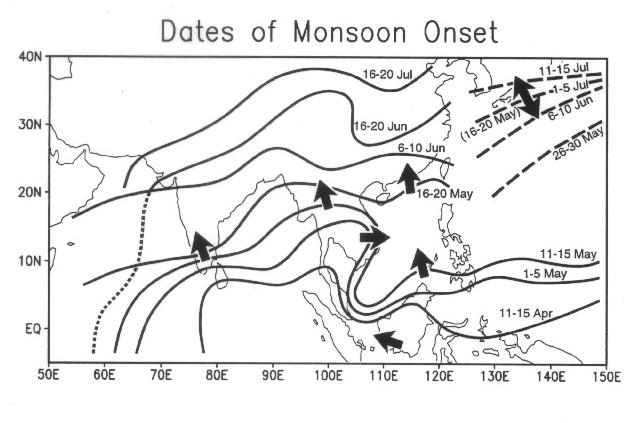
 | Fig. 1. Mean onset date of the Asian summer monsoon adopted from Tao and Chen (1987; isochrones over India from Rao 1976). |
| Editor's Note: The figures are reduced from the original size but if you click on the figure, you can see the full size one. |
|
In this paper, results from a pilot study for the South China Sea Monsoon Experiment are reported. Based on analyses of 9 years of pentad and monthly mean data, the climatology of subseasonal features and interannual variability of the Southeast Asian monsoon (SEAM) are documented. The present analysis is
focused on the sudden onset of the South China Sea monsoon and its relation to the atmospheric and oceanic processes on the entire Asian monsoon region.
It is found that the onset of the SEAM occurs around mid-May, signaling the earliest stage of the entire Asian summer monsoon system. The establishment of monsoon rainfall over the South China Sea is abrupt, being accompanied by substantial changes in the large scale atmospheric circulation and sea surface temperature in the adjacent oceans. The onset and fluctuations of SEAM involve the interaction and metamorphosis of the large scale convection over the Indo-China, the South China Sea and the southern Bay of Bengal. Results show that the onset time of the SEAM differs greatly from one year to another. The delayed (advanced) onset of the monsoon may be related to basin-wide warm (cold) events of the Pacific and Indian Oceans. We also present evidence showing that the SEAM fluctuations in May may foreshadow the development of the full-scale Asian summer monsoon during the subsequent months. Key words: Southeast Asian monsoon, South China Sea, climatology, onset, interannual variability |
Compared to the South Asian and East Asian monsoons, the Southeast Asian monsoon (SEAM), prevailing over the land region of Indo-China, southern China, the South China Sea (SCS), and the Philippines in the late boreal spring, has received relatively less attention in the scientific literature. Yet, considering its regional and global socio- economic impacts, SEAM is no less, if not more important, than the South Asian and East Asian monsoons. Indeed, over a third of the total population of the monsoon Asia resides in Indo-China, southern China, and the maritime continent surrounding the SCS. These regions have been the major supplier of raw materials, agricultural products, fisheries and industrial outputs not only for the entire monsoon regions but for the rest of the world (SCSMEX Science Plan, 1995). Chronologically, SEAM occurs in late boreal spring and early summer, well before the full-scale northward advance of the monsoon in South and East Asia. This is evident in the climatological onset dates of monsoon shown in Fig. 1. More importantly, recent studies have shown that anomalous convection over the SCS and the Philippines may have major impacts on the summertime occurrence of drought and flood over East Asia and Japan (Nitta 1987; Huang 1990). The success of seasonal-to-interannual rainfall forecast in East Asia is primarily dependent on the accurate monitoring of convection over the SCS. Convection and SST fluctuations over the SCS are also sensitive to basin-wide sea surface temperature (SST) fluctuations in the tropical Indian and Pacific oceans, and may foreshadow the development of the SEAM (Lau 1992; Shen and Lau 1995).
| Fig. 1. Mean onset date of the Asian summer monsoon adopted from Tao and Chen (1987; isochrones over India from Rao 1976). |
Furthermore, SEAM may also play a role in global climate fluctuations. As noted in recent studies, the skill of predictability of the tropical climate system appears to be much reduced during the boreal spring period, resulting in the so-called "spring predictability barrier." It has been suggested that the reduced predictability may be related to the influence of the Asian monsoon (Webster and Yang 1992; Lau and Yang 1996). Notably, SEAM is the only large scale convective system occurring during the boreal spring that is capable of imparting extensive tropical surface wind anomalies which may in turn, influence the evolution of the tropical ocean-atmosphere system. Hence, the SEAM is important not only as a regional phenomena but also as an integral part of the global monsoon-ocean-atmosphere climate system. Because of the lack of observations, most of the work on the SEAM, including this one, relies on indirect satellite information and analyses from large scale numerical weather prediction models. As such, most of the data used is unvalidated. To remedy this situation, a multi-national South China Sea Monsoon Experiment (SCSMEX, see discussion in Section 6) has been proposed. This paper is the first of a series of pilot studies for SCSMEX, aiming at providing a basic description and preliminary understanding of SEAM in both its regional and global contexts.
In Section 2, we describe the data used in this study. In Section 3, we document the climatology of rainfall and large scale circulation that are associated with the seasonal march and abrupt transition of the SCS monsoon. In the same section, we also show the basic patterns of variation of tropical convection over the SCS and western Pacific. In Section 4, we discuss the interannual variability of the SEAM and its relation to the atmospheric circulation over the entire monsoon region and vicinity. A summary discussion is given in Section 5, which is followed by concluding remarks in Section 6.
The other key data sets used in this study are the wind and geopotential height form the NASA Data Assimilation Office (DAO) reanalyses for the period 1985-1993. The DAO products have a horizontal resolution of 2ˇ latitude by 2.5ˇ longitude and are produced by 4-D data assimilation using a current version of the Goddard Earth Observing System GCM (GEOS-GCM VC5.7). The system assimilates into the GEOS GCM, satellite data, as well as upper air and surface data available through the Global Telecommunication System (GTS). Schubert et al. (1993) have provided a detailed description of the data assimilation system and products. As stated in the introduction, because of the lack of observations over tropical oceans, these reanalysis products are the only data source for studying the broad-scale features of the Asian monsoon circulation. Also used in the present analysis is weekly 1ˇx1ˇ SST analysis data from the U.S. National Center for Environmental Prediction (NCEP) for the period from 1985 to 1994. The weekly SST combines in situ and satellite observations from operational data produced by the NOAA/NESDIS (Reynolds and Smith 1994). We have linearly interpolated the weekly SST to produce daily values, from which pentad means are computed to match the GPI pentad data.
Figures 2c and 2d show the climatological mean of 200 mb velocity potential for the period 1985-1993. It can be seen that a large scale upper level divergent center is located over Southeast Asia and the western Pacific during both May and June. As stated in the introduction, this divergent center and the associated outflow play an important role in controlling the short-term variability of regional and global climate. From May to June, the divergence strengthens significantly, consistent with the increasing vigor of the monsoon rainfall. It is interesting to note that the divergent center does not overlap rainfall maximum but overlies a region to the east of maximum rainfall. During May, the divergent center is over the SCS. In the next month, it expands into the western Pacific where the monsoon rainfall is less pronounced compared to that over the Bay of Bengal and Indo-China (see Figs. 2a and 2b). The reason for this phase relationship between rainfall and the large scale divergent circulation is unclear. It may be related to the different mechanisms responsible for the organization of large scale circulation by oceanic vs. land convection.
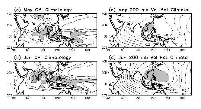 | Fig. 2. (a) and (b): Monthly climatology of GPI (mm per day; 1986-1994) for May and June. (c) and (d): Monthly climatology of 200 mb velocity potential (x107 m2s-1; 1985-1993), also for May and June, from GEOS data assimilation system. |
Similar to its counterparts of South Asia and East Asia, the SEAM possesses a very pronounced subseasonal scale variability including onsets and breaks (see Fig. 3). From April to early May, active convection is anchored to the land bridge of New Guinea, Borneo, the Malay peninsula and Indo-China, forming the axis of the equatorial ITCZ. Between the third and fourth pentads of May, the convective zone expands into the Indian Ocean, southern Bay of Bengal and the SCS. At this time, a new ITCZ begins to develop over the western Pacific near 5ˇN-10ˇN. Notice that at the time of the SCS monsoon onset and shortly thereafter (21-25 May and 26-30 May), convection over the Bay of Bengal and central Indian Ocean near the southwestern tip of India is also intensified. The three rainfall centers appear to from a large scale, almost continuous rain band linking the Indian Ocean through Indo-China and the SCS to southern Japan. Notice that the SCS remains dry until 11-15 May and convection fills the SCS very rapidly in the next pentad. Immediately following the onset (16-20 May), the convection systems over the Indian Ocean, the southern Bay of Bengal, the SCS, and subtropical western Pacific appear to be all connected. The northwestward migration of the maximum rainfall zone over the Indian Ocean and the Bay of Bengal occurs more steadily compared to that over the SCS (see also Fig. 2). The Indian Ocean convection ultimately leads to the onset of monsoon over the Indian subcontinent in early to middle June, whereby the monsoon enters its mature and most vigorous stage.
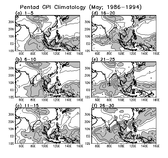 | Fig. 3. Pentad GPI climatology for the various pentads of May. |
The aforementioned abrupt SCS monsoon transition can be seen from Fig. 4a which shows the seasonal and subseasonal variations of the climatological GPI over the southern (5ˇN), middle (10ˇN-15ˇN), and northern (20ˇN) portions of the SCS (along 115ˇE). The central SCS remains very dry from January through mid-May, when the explosive growth in convection occurs and signals the onset of the SCS monsoon. The rainfall of the southern SCS is largest for most part of the year except in June through August, when it is surpassed by the heavy monsoon rainfall over central SCS. The rainfall in the northern SCS adjacent to the southern China coast tends to be less strong compared with the central and southern SCS all year round. It is noticed that the rainy period in northern SCS begins in late April to early May at about the same time as that near the equator. The northern SCS rainfall regime is associated with the so-called pre- rainy season of South China which has been studied extensively by Asian meteorologists. The presence of intraseasonal oscillations of periods 30-60 days is quite evident in all three regions of the SCS. There also appears to be a slightly time-delayed inverse relationship between convection in the central and northern SCS. This becomes more evidence in the results that will be shown in Section 4.
 |
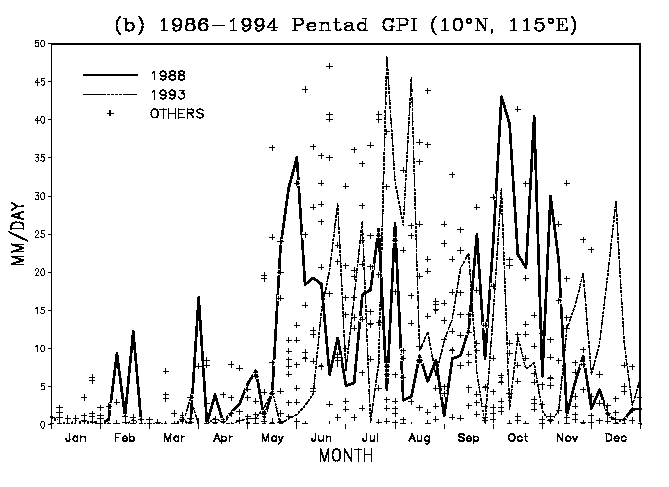 |
| Fig. 4. (a) Pentad climatology of GPI for the southern (5\041N), central (average of 10\041N and 15\041N), and northern (20\041N)South China Sea. (b) Pentad GPI at point 10\041N, 115\041E for each year from 1986 to 1994. The years of 1988 and 1993 are shown by solid and dotted lines to demonstrate early and late monsoon onset respectively. Other years are shown by "+" sign. |
Both the intensity and the onset time of the SCS monsoon vary greatly from year to year. Figure 4b shows the time history of GPI at central SCS for all pentads from 1986 to 1994. To demonstrate the bounds of the onset date, the time series of an early-onset year (1988) and a delayed-onset year (1993) are highlighted. The data points for all other years are denoted by the "+" sign. The early onset of the SCS monsoon in 1988 is quite obvious. There appear to be enhanced though still unorganized convective activities in central SCS as early as March to April. The explosive growth of the central SCS convection is quite remarkable in 1988. In contrast, the onset of the 1993 monsoon does not begin until mid-June. This rather wide time window in onset dates implies that the onset dates are controlled by many different factors. Atmospheric internal dynamics, intraseasonal oscillation, SST, and land surface conditions over Southeast Asia and the interior of the Asian continent may all play a role. They are also the reasons for the low skills in the prediction of regional monsoon onset. It is clear from the above discussions that the exact dates for the onset of the SCS monsoon are not well-defined and depend on the definition used. This is true for all the regional scale monsoons. As a summary of the above discussion, we provide in Fig. 5, a picture of the "onset days" of the monsoon at each point based on the GPI . This figure is used to portrait the evolution of rainfall regimes for the entire Asian monsoon although the exact time and location should be taken with cautions. We use the GPI contours of 6 mm per day to denote the northern extend of monsoon rain zone. Figure 5 shows clearly a northward and northwestward advance (indicated by the direction of the arrows) of the monsoon system over the land region in agreement with that shown in Fig. 1 using gauge data. However, Fig. 5 reveals additional information concerning the SEAM over the oceanic regions which are not shown in Fig. 1. For example, Fig. 5 shows an earlier monsoon onset in southern India. The monsoon onset over South China appears later in Fig. 5 than in Fig. 1 in which the rainfall during pre-monsoon season is included. The pre-monsoon rain is generally associated with moderate rain in stratiform cloud decks, lacking deep vertical development. Thus, this type of rain cannot be properly detected by the GPI. The most pronounced feature regarding SEAM is the sudden northward surge of the rain belt over the SCS during mid-May. The anchoring of the monsoon convection by the land topography is quite evident from the closely packed contours near the southern tip of the Malay peninsula and the Indian subcontinent. Another noteworthy feature is that the monsoon rainfall "retreats" eastward rather rapidly over the western Arabian Sea during mid-June (shown as dotted line in Fig. 5). A set of dashed contours over the Japan and Korea regions is used to depict the migration of Baiu and Changma. Variations of these phenomena, which exhibit an oscillative nature, involve mechanisms which are probably different from those responsible for the SCS monsoon (Ho et al. 1996).
 | Fig. 5. The onset date of summer monsoon in different Asian regions determined by the GPI contours of 6 mm per day. |
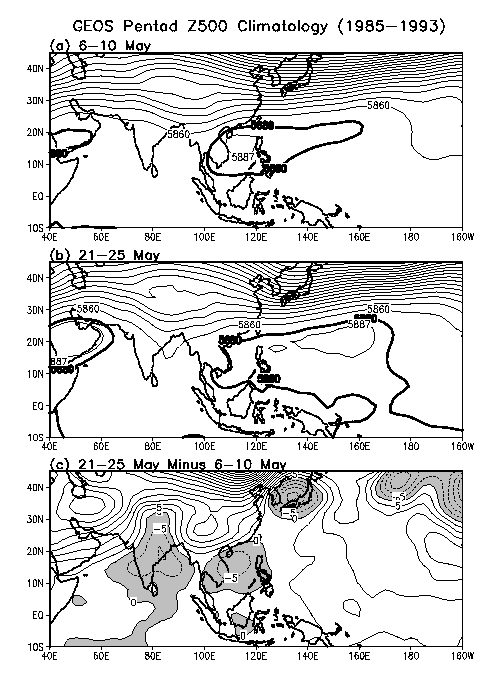 | Fig. 6. Pentad climatology (1985-1993) of 500 mb geopotential height (m) from the GEOS data assimilation for 6-10 May (a; before the SCS monsoon onset) and 21-25 May (b; after the SCS monsoon onset). The areas of high pressure center are shaded. Shown in (c) is the difference of geopotential height between (b) and (a). |
Before the monsoon onset, low level easterlies prevail over the SCS, under the prevailing influence of the WPSH (Fig. 7a). After the onset (Fig. 7b), the subtropical high retreats eastward while the low-level westerly flow from the equatorial Indian Ocean extends into the SCS. A confluence of the easterlies and westerlies occurs over the Indo-China peninsula and Malaysia where the heaviest rainfall appears (see Fig. 3b). After monsoon onset, local circulation over the SCS switches from anticyclonic to cyclonic, with strong southerly flow over the SCS and South China. The anomalous cyclonic circulation over the SCS is quite evident in the difference map shown in Fig. 7c. Also evident is the simultaneous development of anomalous cyclonic circulation over the Bay of Bengal and Japan. As noted before these cyclonic disturbances appear to have deep vertical structure extending up to 500 mb (Fig. 6). Although monsoon onset has not yet begun in India at this time, the westerlies to its south over the Indian Ocean are well established. The flow patterns shown in Fig. 7a and Fig. 7b resemble respectively those for the active and break monsoon over the SCS and the western Pacific (Yang 1983; Chen and Weng 1996). Chen and Weng showed that eastward-propagating (westward-propagating) equatorial waves were more vigorously associated with the active (break) monsoon patterns.
 | Fig. 7. Same as Fig. 6 but for 850 mb winds (ms-1). |
The changes in the upper tropospheric circulation associated with the SCS monsoon can be seen from Fig. 8. During late spring and early summer, the entire South and Southeast Asia is under the control of a large scale anticyclone with strong westerlies between 25ˇN-40ˇN and easterlies from equator to 10ˇN. This represents the beginning stage of the Tibetan or South Asian Anticyclone. Associated with the onset of monsoon, the anticyclone intensifies and becomes concentrated over the Indo-China region. Also evident is the strong northeasterly outflow emanating from the SCS after the onset. The strengthening of the upper level easterlies near 20ˇN is very pronounced in the difference map shown in Fig. 8c. Two large scale anticyclonic circulation cells appear over the interior of the Asian continent and the Middle East. The intensification of these upper tropospheric highs at the time of the SCS monsoon onset may be linked to an increase in atmospheric diabatic heating associated with the establishment of heat source over the Tibetan Plateau (Luo and Yanai 1984; He et al. 1987; Yanai et al. 1992).
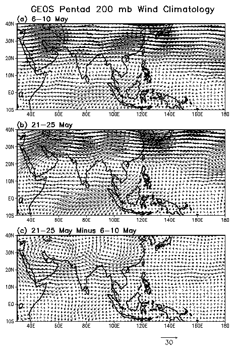 | Fig. 8. Same as Fig. 6 but for 200 mb winds (ms-1). |
Overall, the large scale circulation features including the low level cyclonic development the upper anticyclones are dynamically consistent with the forcing by enhanced convection over the SCS during the onset. At the lower level, the cyclonic circulation associated with the development of the low pressure center and the deep core structure is a signature of latent heating induced atmospheric circulation. At the upper level, the rising motion generated by latent heating causes divergent motion which, through the b effect and vorticity balance requirement, forces an anticyclone to form westward of the heating, whereby inducing equatorward motion over the SCS. This is consistent with basic mechanism for the formation of the subtropical high proposed by Hoskins (1996).
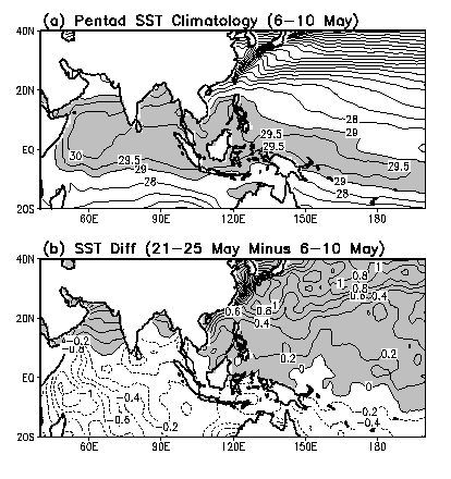 | Fig. 9. SST climatology (\041C) for 6-10 May (a) and the difference in climatological SST between 21-25 May and 6-10 May (b). |
The above results indicate that the onset of the SCS monsoon represents a major shift in the large-scale atmospheric circulation and SST over the entire Asian monsoon region. To provide a better understanding of the SST variability in different ocean domains, we show in Fig. 10 the annual cycle of SST, based on pentad data averaged within 5ˇN-20ˇN for the SCS, Bay of Bengal, Arabian Sea and the western Pacific, respectively. The Pacific SST is warmer than the SST of other domains from July to February but becomes much cooler from April to June. The maximum SST is reached in September, about three months behind the summer solstice. The annual variation of the western Pacific SST suggests a delayed response of about three months to the direct thermal forcing from the seasonal variation of insolation reaching the ocean surface and implies a minimum impact from the monsoon.
 | Fig. 10. Pentad climatology of 5\041N-20\041N averaged SST shown for different ocean domains. |
In contrast, the SST of the Arabian Sea and the Bay of Bengal possess a semi-annual structure, implying a strong impact from the Asian monsoon. The first maximum occurs in mid-May and the second at the end of October. The lowest Arabian Sea SST is reached during August, and the second lowest in January. The summertime minimum is a response to the monsoon. The reduction in SST is most dramatic in the Arabian Sea from the middle of May through August, with a decrease by more than 4ˇC. In the Bay of Bengal, the SST response to the monsoon is also quite strong, with a SST reduction of about 1.5ˇC. Compared to the Arabian Sea and the Bay of Bengal, the annual variation of SST in the SCS is quite different. It represents a transition zone between the Indian Ocean and the western Pacific. Here, the SST is considerably lower than the other oceans from November to March. After the monsoon onset in mid-May, the SCS SST becomes higher than that in the Bay of Bengal and Arabian Sea and appears to be least affected by the monsoon. The apparent resilience of the SCS SST to the monsoon wind change is due to the warming in the northern SCS which compensates the monsoon induced cooling in the south (e.g., see Fig. 9b). The warming in the north may be related to the advection of warm water from the southern SCS and the Java sea after the monsoon onset (Chu et al. 1993).
It should be noticed in particular that the cooling of the Arabian Sea and Bay of Bengal begins before the onset of the Indian monsoon which occurs in June. An analysis of surface winds and latent heat flux from the Comprehensive Ocean-Atmosphere Data Set (not shown) indicates consistently that during May both the wind speed and latent heat flux are substantial over the Arabian Sea and Bay of Bengal but much smaller over the SCS. It is conceivable that the temperature differential caused by radiation and monsoon forcing (e.g., warmer SST in the SCS and cooler SST in the Arabian Sea and Bay of Bengal) may in turn provide a feedback to the monsoon evolution. The continual warming of the SST in the northern SCS may contribute to the vigor of the regional monsoon after its establishment. On the other hand, the slow northward migration of the monsoon over the Arabian Sea and Bay of Bengal during late spring and early summer may be related to a negative feedback triggered by the monsoon-induced cooling of the adjacent oceans.
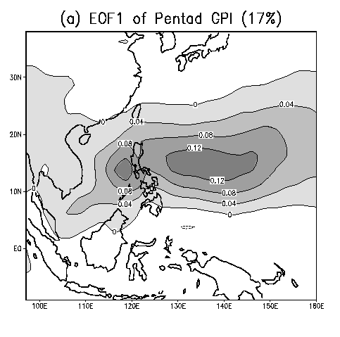 | 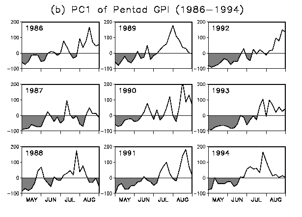 |
| Fig. 11. Pattern of the greatest eigenvector of pentad GPI (a) and time series of the corresponding principal component (b). Calculations are based on pentad GPI for the months of May-August from 1986 to 1994. |
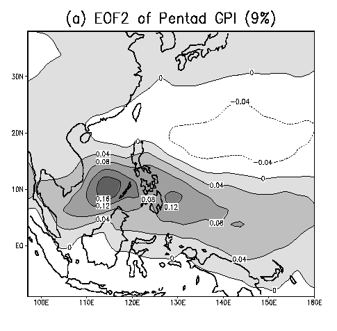
Figure 12 presents the corresponding information of Fig. 11 but for the second EOF. This mode captures mainly the rainfall variability over the central part of the SCS (Fig. 12a). Of interest is the appearance of a seesaw relationship between the SCS rainfall and the region of the WPSH which extends into the northern SCS. The seesaw of rainfall variation may be related to the differential warming between the northern SCS and the central-southern SCS noted in the previous section. The time series in Fig. 12b portraits clearly the subseasonal variability of the SCS rainfall especially the onset of the SCS monsoon. It is obvious that the monsoon begins early in some years but late in other years. Delayed monsoon onsets with suppressed convective activity in the central SCS from May to mid-June are quite evident in 1987, 1991, 1992, and 1993. It should be noticed that 1987 is an El Ni–o year and the 1991-1993 period is characterized by continuous warning of the equatorial eastern Pacific in the form of a series of mini-El Ni–os (Goddard and Graham 1996). A similar relationship between ENSO and the East Asian monsoon has been reported in previous studies (Chen et al. 1991; Shen and Lau 1995). A number of numerical studies (e.g., Ju and Slingo 1995; Soman and Slingo 1996; Yang and Lau 1996) have also indicated that the central-eastern Pacific SST anomaly may exert the strongest impact on the Asian monsoon during May.
 |
 |
| Fig. 12. Same as Fig. 11 but for the pattern of the second EOF and time series of its corresponding principal component. |
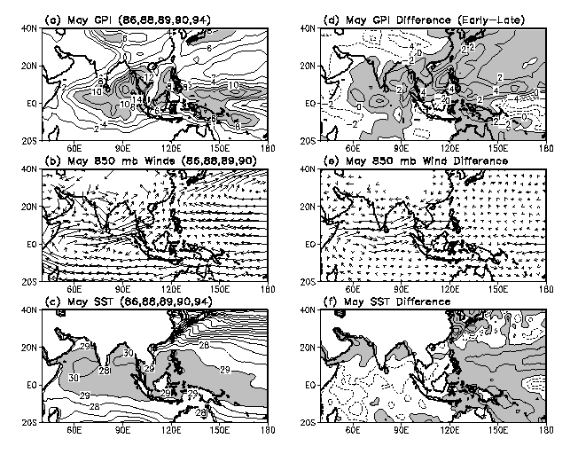 | Fig. 13. Composite patterns of GPI (a), 850 mb winds (b) and SST (c) for May of early monsoon onset years (1986, 1988, 1989, 1990, and 1994). Also shown are the differences in these fields (d-f; right panels) between the early years and late monsoon onset years (1987, 1991, 1992, and 1993). |
The May anomaly patterns have a strong projection onto the following seasonal (JJA) anomalies for the same years (Fig. 14). When the SCS monsoon occurs earlier than normal, the full scale Asian monsoon in JJA is enhanced with more rainfall over the monsoon region and the western Pacific. The low level westerly wind anomaly remains persistently over the Indian Ocean and southern SCS and the increased easterlies appear again over the central equatorial Pacific. A low level cyclonic circulation is formed over the subtropical western Pacific in the region of enhanced rainfall. This low will effectively move the WPSH eastward and substantially reduce the control of the WPSH on East Asian monsoon. A comparison between Fig. 13f and Fig. 14f indicates that the major features of May SST remain in the JJA SST pattern.
 | Fig. 14. Same as Fig. 13 but for JJA patterns. |
The SEAM is an integral part of the Asian monsoon system. It has enormous influence on local weather and climate of Southeast Asia. The onset of the SEAM marks the earliest stage of the Asian monsoon, when strong land-locked convection rapidly develops into deep and organized convective systems over the SCS and the Bay of Bengal with pronounced monsoonal characteristics.
The time of onset of the SCS monsoon is around mid-May, but there is a large variability from year to year with onset occurring as early as late April to early June. The delayed and early onset of the SCS monsoon may be related to the basin-wide warm and cold events over the Pacific and Indian oceans.
The onset and fluctuations of the SCS monsoon are important not only as a local phenomenon, but also as indicators of the interaction of major convection and circulation systems over the western Pacific, the Indian Ocean and the interior of Asia, as well as significant SST anomalies in the adjacent oceans. The SCS convection and Bay of Bengal disturbances appear to be closely linked at the onset time of the SCS monsoon.
The development of the SEAM may foreshadow the strength of the full-scale Asian monsoon in June through August. The most pronounced signal is the enhanced surface westerlies over the equatorial Indian Ocean and easterlies over the equatorial western Pacific.
Chen, G. T.-J. (1996), The large-scale features associated with the Meiyu over South China and Taiwan. From Atmospheric Circulation to Global Change, Ed. by IAP Chinese Academy of Sciences, China Meteorological Press, 289-313.
Chen, L., Q. Zhu, H. Luo, J. He, M. Dong and Z. Feng (1991), East Asian Monsoon. Meteorological Press, pp. 362 (in Chinese).
Chen, T.-C., and S.-P. Weng (1996), Some effects of the intraseasonal oscillation on the equatorial waves over the western tropical Pacific-South China Sea region during the northern summer. Mon. Wea. Rev., in press.
Chu, P. C., C. Li, D. Ko and C. N. K. Mooers (1993), A numerical simulation of seasonal circulation in the South China Sea. AGU Fall Meeting, San Francisco, California, 6-10 December 1993.
Ding, Y., Q. Wang and J. Yan (1996), Some aspects of climatology of the summer monsoon over the South China Sea. From Atmospheric Circulation to Global Change, Ed. by IAP Chinese Academy of Sciences, China Meteorological Press, 329-339.
Goddard, L., and N. E. Graham (1996), El Ni–o in the 1990's. J. Geophys. Res., submitted.
He, H., J. W. McGinnis, Z. Song and M. Yanai (1987), Onset of the Asian monsoon in 1979 and the effect of Tibetan Plateau. Mon. Wea. Rev., 115: 1966-1995.
Ho, C., et al (1996), The abrupt transitions and multiple onsets associated with the East Asian monsoon. Mon. Wea. Rev., submitted.
Hoskins, B. (1996), On the existence and strength of the summer subtropical anticyclones. Bull. Amer. Meteor. Soc., 77: 1287-1292.
Huang, R. (1990), The East Asia/Pacific pattern teleconnection of summer circulation and climate anomaly in East Asia. Climate Change Dynamics and Modelling, China Meteorological Press, 127-140.
Janowiak, J. E., and P. Arkin (1991), Rainfall variations in tropics during 1986-1989 as estimated from observations of cloud top temperature. J. Geophys. Res., 96: 3359-3373.
Ju. J., and J. Slingo (1995), The Asian summer monsoon and ENSO. Quart. J. Roy. Meteor. Soc., 121: 1133-1168.
Krishnamurti, T. N. (1985), The Summer monsoon Experiment: A review. Mon. Wea. Rev., 113: 1590-1626.
Lau, K.-M. (1992), East Asian summer monsoon rainfall variability and climate teleconnection. J. Meteor. Soc. Japan, 70: 211-242.
Lau, K.-M., G. J. Yang and S. Shen (1988), Seasonal and intraseasonal climatology of summer monsoon rainfall over East Asia. Mon. Wea. Rev., 116: 18-37.
Lau, K.-M., and M. T. Li (1984), The monsoon of east Asia and its global association. Bull. Amer. Meteor. Soc., 65: 114-125.
Lau, K.-M., and S. Yang (1996), The Asian monsoon and predictability of the tropical ocean-atmosphere system. Quart. J. Roy. Meteor. Soc., 122: 945-957.
Luo, H., and M. Yanai (1984), The large-scale circulation and heat sources over the Tibetan Plateau and surrounding areas during the early summer of 1979: Part II: Heat and moisture budgets. Mon. Wea. Rev., 112: 966-989.
Ninomiya, K. (1989), Cloud distribution over East Asia during Baiu period of 1979. J. Meteor. Soc. Japan, 67: 639-658.
Nitta, T. (1987), Convective activities in the tropical western Pacific and their impact on the northern hemisphere summer circulation. J. Meteor. Soc. Japan, 41: 373-390.
Rao, Y. P. (1976), Southwest monsoon. Meteorology Monographs, Synoptic Meteorology, Indian Meteorological Department. Reynolds, R. W., and T. M. Smith (1994), Improved global sea surface temperature analyses using optimum interpolation. J. Climate, 7: 929-948.
Schubert, S. D., R. B. Rood and J. Pfaendtner (1993), An assimilated dataset for earth science applications. Bull. Amer. Meteor. Soc., 74: 2331-2342.
SCSMEX Committee (1995), The South China Sea monsoon experiment (SCSMEX), Science Plan, pp. 65.
Shen, S., and K.-M. Lau (1995), Biennial oscillation associated with the East Asian summer monsoon and tropical sea surface temperatures. J. Meteor. Soc. Japan, 73: 105-124.
Soman, M. K., and J. Slingo (1996), Sensitivity of Asian summer monsoon to aspects of sea surface temperature anomalies in the tropical Pacific Ocean. Quart. J. Roy. Meteor. Soc., in press.
Tao, S. and L. Chen (1987), A review of recent research on the east Asian summer monsoon in China. Monsoon Meteorology, Ed. by C.-P. Chang and T. N. Krishnamurti, Oxford University Press, pp. 60-92.
Webster, P. J., and S. Yang (1992), Monsoon and ENSO: Selectively interactive systems. Quart. J. Roy. Meteor. Soc., 118: 877-926.
Yanai, M., C. Li and Z. Song (1992), Seasonal heating of the Tibetan Plateau and its effects on the evolution of the Asian summer monsoon. J. Meteor. Soc. Japan, 70: 319-351.
Yang, S. (1983), Characteristics and structures of the atmospheric circulation in Southeast Asia during the active and break periods of the southwest monsoon. Proceedings of the Symposium on the Summer Monsoon in Southeast Asia-1981, Yunnan People's Press, 49-63 (in Chinese).
Yang, S., and K.-M. Lau (1996), Influences of SST and ground wetness on the Asian summer monsoon. J. Climate, submitted.
Drs. William K.-M. Lau and Song Yang