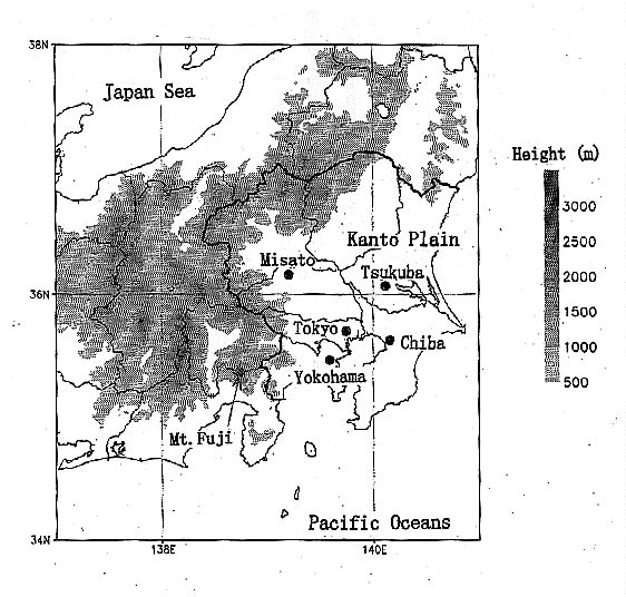
 | Fig. 1. Map and orography of the Kanto area. |
Masanori Yoshizaki and Hajime Nakamura
Forecast Research Department
Meteorological Research Institute/Japan Meteorological Agency
1-1, Nagamine, Tsukuba, Ibaraki, Japan 305
| Fig. 1. Map and orography of the Kanto area. |
The Kanto area has several metropolitan cities (Tokyo, Yokohama, Chiba and so on) and about 40 million inhabitants. Industrial, commercial, and agricultural activities are very active. Thus unexpected mesoscale local circulation and severe weathers cause a great deal of damages to our society. Therefore, advanced forecasts of such disturbances are required. However, observational and numerical studies for structures and formation mechanisms of these disturbances are few, and so it is urgent to make their observations.
Long-term observations are necessary, because occurrences of such disturbances are not frequent. Fortunately, there are many observational instruments and researchers in the Kanto area, and occasional observations are possible jointly. In 1993, TAPS was organized by voluntary participants of national institutes, universities and private enterprises, and started observations by using participants* instruments and fund. Here we want to introduce research activities of TAPS in the past and future.
Several results are shown in the following:
Seko et al. (1997) examined mesoscale wind structure of the autumnal stationary front (Akisame front) on 22 September 1993. Over Tsukuba, a three-layered wind structure was found, which was composed of easterly wind below the height of 2 km, weak northerly wind between 2 and 3 km, and southerly wind above 3 km. It persisted for more than 9 hours. It was shown from weather maps, analyzed cloud charts of the Geostationary Meteorological Satellite, and Radar-AMeDAS precipitation charts, that the three-layered wind structure was seen near or at the northern side of the moderate precipitation areas in a stratiform cloud band, which was located on the northern side of the Akisame front (Fig. 2). The complicated horizontal wind fields such as a wedge of the northerly wind layer were clarified by using data of Doppler radar at Tsukuba with the simplified Volume Velocity Processing Method.
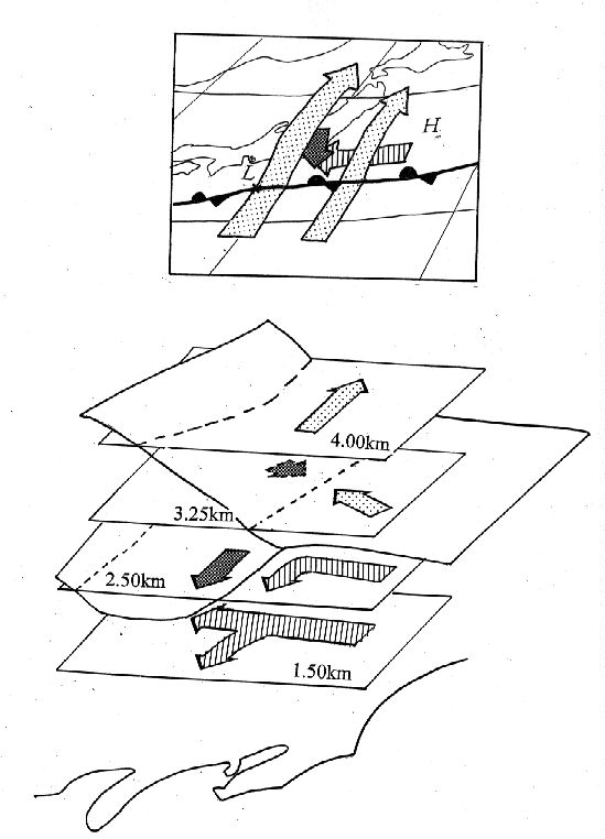 | Fig. 2. Schematic flow fields in the Akisame front on 22 September 1993 (Seko et al. 1997). |
Takayama et al. (1997) analysed downbursts occurred on the northwestern part of Kanto area on 8 September 1994. In the afternoon, a severe thunderstorm passed on the northern part of Kanto area. The wind produced damage to window glass of the Misato Junior High School (MJHS), injuring 2 teachers and 71 students. The damage-producing wind and its parent thunderstorm were analyzed by using data from a damage survey, surface meteorological stations, upper air soundings, satellite images and a conventional radar. Time-space converted wind data at several surface stations showed that divergent wind fields, corresponding to downbursts A and C, occurred near the times and locations of these events (Fig. 3).
 | Fig. 3. Wind fields obtained by time-space conversion of wind data at several observational stations at 1436JST when the damage-producing wind occurred at MJHS (Takayama et al. 1997). The locations of MJHS and other observational stations are indicated by triangle and large solid circles, respectively. The characters of A, B, and C surrounded by dotted lines denote the areas of the divergent wind originated in downburst A, B, and C, respectively. The direction and the speed of the storm motion is assumed to be 125 degrees and 8m/s, respectively, from the movement of the echo observed by Mt. Fuji radar. |
Yoshizaki et al. (1997) studied thunderstorms occurred on 10 August 1995 from the standpoint of three horizontal scales; synoptic-scale (1000km), Kanto-scale (100km) and storm-scale (10km) (Fig. 4). The storms occurred when synoptic-scale cold front passed over the Kanto area. Over the Kanto Plain, three distinct wind systems (very warm southerly wind I, warm northwesterly wind II and cold northeasterly wind III) and (wind) shear lines were seen, before the storms appeared. Each wind system has properties of mini-airmass, in which temperature and humidity are nearly uniform. The storm concerned here initiated near the intersection of three shear lines. At the mature stage of the storm, downdraft and outflows by intense precipitation were seen as the storm-scale flow, and arc-shaped clouds developed along the edge of outflows. It is concluded that diabatic effects such as evaporation of rain are essential for the formation of cold northeasterly wind in the wind system III.
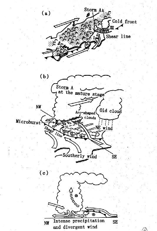 | Fig. 4. Conceptual flow fields of Storm A on 10 August 1995 at (a) initial and (b, c) mature stages (Yoshizaki et al, 1997). |
Besides, analytical and numerical studies of tornadoes, squall lines, rainband associated with typhoon, warm front, heavy snowfall associated with cyclones, and local fronts were being progressed.
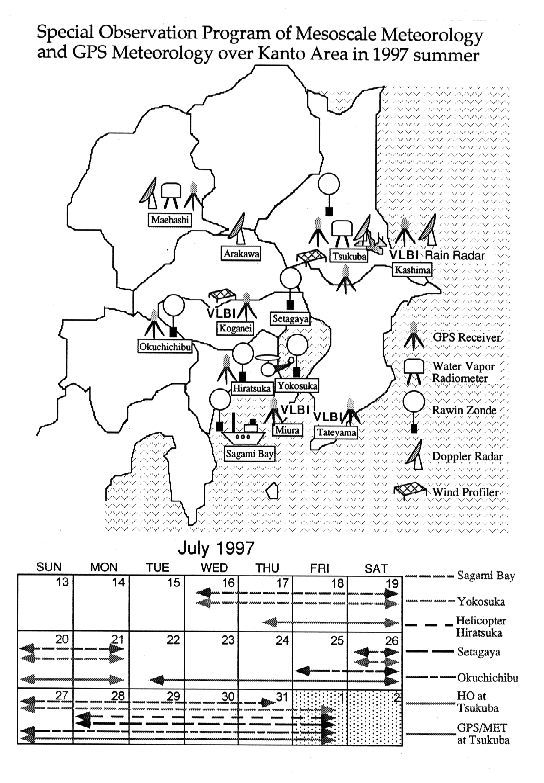 | Fig. 5. Locations of observation instruments in special observation on July 1997. |
Takayama, H., H. Niino, S. Watanabe, J. Sugaya and Members of Tsukuba Area Precipitation Studies, 1997: Downbursts in the northwestern part of Saitama prefecture on 8 September 1994. Accepted by J. Meteor. Soc. Japan.
Yoshizaki, M., N. Uekiyo, H. Seko, H. Takayama, K. Kusunoki and Members of Tsukuba Area Precipitation Studies, 1997: Analysis of thunderstorms occurred over the Kanto Plain on 10 August 1995. Submitted to Tenki (in Japanese).