 planetary boundary layer
parameterization scheme. In this article, for the limitation of the paper
length, we only discuss the forecasts using LFS with the fine-grid.
planetary boundary layer
parameterization scheme. In this article, for the limitation of the paper
length, we only discuss the forecasts using LFS with the fine-grid.
Simon W. Chang
Naval Research Laboratory, Washington, DC, USA
The 2nd generation of Limited Forecast System (LFS)
of Taiwan Central Weather Bureau (CWB) has been
operating since 1994, which has two runs daily (0000 UTC and
1200 UTC). LFS is a nested second order
finite differencing model which has coarse grid (grid
points: 161x121, grid size: 60 km, 48 h forecasts), and
fine grid (91x91, 20 km, 36 h forecasts), using split-explicit temporal
integration scheme and Kuo (1974)
cumulus scheme, Harshvardhan et al. (1987) radiation
scheme, TKE E- planetary boundary layer
parameterization scheme. In this article, for the limitation of the paper
length, we only discuss the forecasts using LFS with the fine-grid.
We have studied the forecasts of LFS in detail during the Mei-Yu season (there exists a heavy rainfall season from early May to late June in Taiwan area) this year. Wherever the direction of weather system is moving (to sea or still on land), the preliminary results have shown that they have good performance for weather systems larger than one hundred kilometer when the initial conditions of LFS involve almost all the weather systems. That is, the dynamics and physics of LFS could simulate all the weather systems. But if there exist some unknown mechanisms in a weather system, whice are not caught in the initial conditions, LFS would have not enough information to such weather system eventually, especially on the scale below one hundred kilometer. In this article we use a heavy rainfall case during the Mei-Yu season to describe the performance and improvements of LFS.
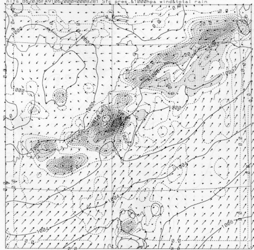
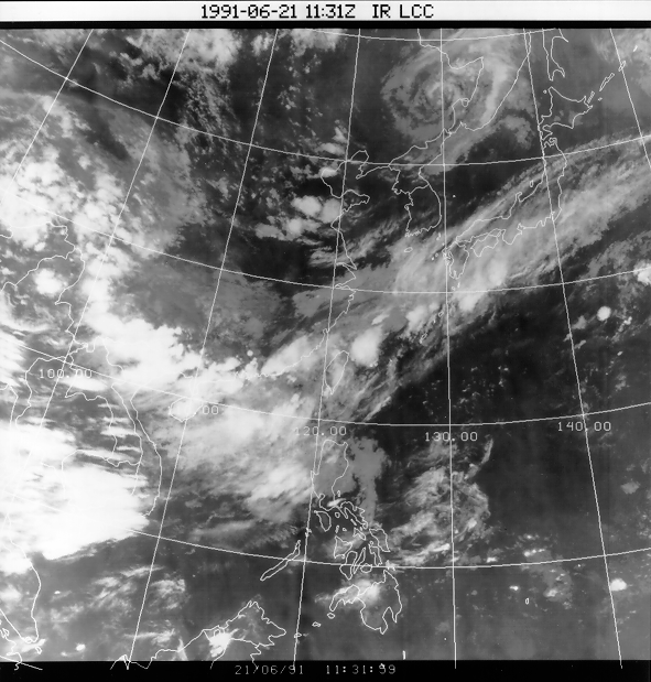
Fig. 1a shows the 36 h forecast of precipitation (12 h
accumulated), sea level pressure and 1000 hPa wind field
of June 20, 1991 with fine-grid LFS. Fig 1b depicts the IR imagery at the same
date as in Fig 1a. Comparing Fig. 1a and 1b, we note that LFS is pretty good in
forecasting the detailed structure of the Mei-Yu front from Taiwan area
to Japan. However, LFS does not produce precipitations from the cloud cluster
from the South China Sea to Philippines due to the shortage of observation data
related to convection in that region. From Fig 1a, it is also shown that
LFS forecasts only a little precipitation on Taiwan island while the satellite
picture shows quite intensive precipitation.
 (a)
(a)
 (b)
(b)
Fig. 1. (a) 36 h forecast of precipitation (12 h accumulated, shading), sea level pressure and 1000 hPa wind field of June 20, 1991 with fine-grid LFS and (b) the IR imagery at the same time.
Recently we have done some tests and are planning to do more tests to improve the performances of LFS, which include the following items:
CWB is planning to develop a non-hydrostatic
model (NHM), which has 5 km grid-size and covers
Taiwan island only. The forecasts of NHM could
involve meso-scale weather systems on the scale from one hundred kilometer to
about twenty-five kilometer, which include most of meso- scale phenomena. It is of
benefit to weather forecasts in Taiwan. But there exist some important and
difficult factors; for example, the initial conditions of NHM may not catch
the detailed charateristics of initial weather system, especially over the
ocean around the Taiwan where the convective-scale observation data are seldom
available. Also the mountains of Taiwan, whose heights often exceeds 3 kilometers, might make the simulations more complicated.
scale phenomena. It is of
benefit to weather forecasts in Taiwan. But there exist some important and
difficult factors; for example, the initial conditions of NHM may not catch
the detailed charateristics of initial weather system, especially over the
ocean around the Taiwan where the convective-scale observation data are seldom
available. Also the mountains of Taiwan, whose heights often exceeds 3 kilometers, might make the simulations more complicated.
Harshvardhan, R. D., D. Randall, and T. Corsetti, 1987: A fast radiation parameterization for the atmospheric circulation model. J. Geohpys. Res., 92, 1009-1016.
Krishnamurti, T. N., H. S. Bedi, W. Heckley, and K. Ingles, 1988: Reduction of spin-up time for evaporation and precipitation in a spectral model. Mon. Wea. Rev., 116, 907-920.
____, J. Xue, H. S. Bedi, K. Ingles, and D. Oosterhof, 1991: Physical initialization for numerical weather prediction over the tropics. Tellus, 43A, 53-81.
Kuo, H. L., 1974: Further studies of the parameterization of the influence of cumulus convection on large scale flow. J. Atmos. Sci., 31, 1232-1240.
Smolarkiewicz, P. K., 1983: A simple positive definite advection scheme with small implicit diffusion. Mon. Wea. Rev., 111, 479-486.
*Corresponding author address:
Dr. Tzay-Ming Leou
Computer Center
Central Weather Bureau
64 Kung Yuan Road, Taipei, Taiwan, ROC
Fax: 8862-349-1279
E-mail: rfs4@gwya.cwb.gov.tw