ENSO Monitoring/Prediction Activities at JMA

Naoyuki Hasegawa, Masayoshi Ishii, Ikuo Yoshikawa, Ichiro Ishikawa

El Niño Monitoring and Prediction Center
Climate Prediction Division
Japan Meteorological Agency
Tokyo, Japan


1. Introduction

ENSO has a great impact on the weather in many parts of the world. The El Niño event that started in the spring of 1997 caused various extreme weather including the severe drought in Indonesia. In Japan, the summer (JJA) temperature tends to be below normal during an El Niño event. It was below normal in Nansei Islands (the southernmost part of Japan) in 1997, and the sunshine duration was below normal in the west Japan as expected from the statistics obtained so far. However, the temperature was above normal over most of Honshu (the main island of Japan) in 1997. The statistics show that temperatures are above normal over Japan during El Niño winter, and this trend was prevailing in the winter 1997/98 in Japan except in the northern part. Japan is off the areas where direct and typical mid-latitude influences of ENSO, known as Pacific North American pattern, are seen. However, the observed above normal temperature may be attributed to the indirect influences of the current event.

As seen in the case of some parts of Japan in the summer 1997, these impacts of El Niño events on the Japanese weather are less consistent than those in tropics. However, ENSO is one of the most helpful clues for seasonal prediction in Japan. For this reason, the El Niño Monitoring Center (now the El Niño Monitoring and Prediction Center) was established at the Japan Meteorological Agency (JMA) in 1992 to monitor ENSO.


2. Ocean Data Assimilation System

The Ocean Data Assimilation System (ODAS) was developed and put into operation in 1994. The system provides a three dimensional structure of the tropical ocean and is an essential tool for the ENSO monitoring at JMA. The system is well documented by Kimoto et al. (1997).

The ODAS consists of a global ocean general circulation model and an ocean data analysis system. The horizontal resolution of the model is 2.0° latitude by 2.5° longitude except in the 20°N - 20°S equatorial band, where the latitudinal spacing is 0.5° within 10° from the equator and is increased outside to 20° latitudes. The model has 20 vertical levels, and most of them are placed in the upper 500m. The model includes Mellor and Yamada's turbulent closure scheme of level 2.5 for vertical diffusion (Mellor and Yamada, 1974, 1982). A nonlinear horizontal diffusion is adopted.

Every 5 days, with the data cut off time of 30 days, the upper ocean temperatures are analyzed based on the observation collected through the Global Telecommunication System. The data include those from research vessels, ships under the Ship of Opportunity Programme (SOOP), as well as buoys such as the TAO array. An optimal interpolation scheme is used for the analysis. Then the model is run for 5 days with the nudging forcing terms in the temperature tendency toward the analyzed temperatures to obtain the assimilation data. No forcing is applied to the velocity fields. Forcing toward the Levitus (1982) climatology is applied to the salinity. The wind stress given to the model is estimated from the JMA operational global atmospheric analysis using a bulk method. No heat flux is given, but instead, the sea temperatures above the analyzed mixed layer depth are forced to the SST analysis with relatively short e-forlding time (5 days).

Figure 1 shows longitude-time diagram of the anomalies of the ocean heat content (OHC; vertically averaged temperature above 260m) and of the zonal wind stress along the equator obtained from the ODAS. The OHC anomalies remained negative in the east and positive in the west until the end of 1996. This pattern is consistent with the stronger than normal trade winds which had persisted since the middle of 1995.


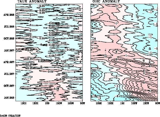
Fig. 1. Longitude-time cross section of the anomalies of the zonal wind stress (left; N/m2) and the ocean heat content (left; averaged temperature between the surface and 260m, °C) along the equator obtained from ODAS


The warm Kelvin wave induced around 150°E in January 1997 is visible in the chart. This was generated by the strong westerly anomaly observed in the lower troposphere at the end of 1996. This warm wave propagated eastward and reached the eastern coast in April. The second warm wave was formed in the west in March and followed the first one to the eastern Pacific. This caused further rise in the OHC in the eastern equatorial Pacific, and led to the warming of the sea surface temperatures there (Fig. 2).


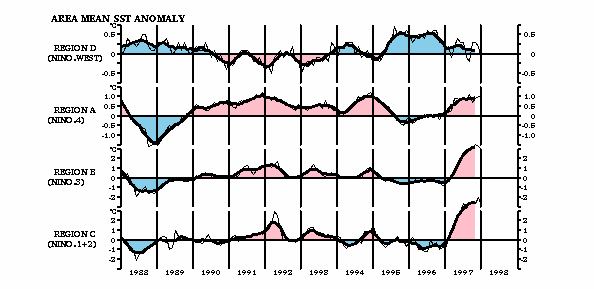
Fig. 2. The time series of the area mean sea surface temperature anomaly (°C) over (from the top) Region D (130°E - 150°E, 14°N - Equator), Region A (160°E - 150°W, 4°N -4°S), Region B (150°W - 90°W, 4°N -4°S, almost equivalent to NINO3), and Region C (90°W - 80°W, Equator - 10°S).


Figure 3 indicates the longitude-depth cross sections of the temperatures along the equator in February, May, August, and November 1997, and February 1998. In February 1997, the warm anomaly is still centered in the western half of the Pacific. In May, when the onset of the El Niño event is evident in SST, the warm anomalies are spread almost in the entire equatorial Pacific along the thermocline. In August, negative anomaly was clearly found in the west. In November, when the SST anomaly in NINO3 was at the peak, the negative anomaly in the west and positive anomaly in the east were intensified and east west contrast was very clear. The cold anomaly in the west further strengthened and expanded eastward in February 1998. Thus the subsurface temperature features of different phases of the event are identified, and thier usefulness in the monitoring of ENSO is evident.


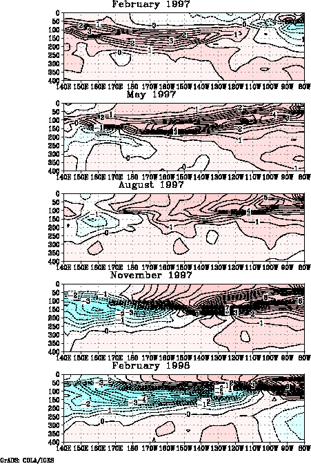
Fig. 3. Longitude-depth cross sections of temperatures anomalies (°C) along the equator.


3. ENSO Prediction

JMA has developed a coupled ocean and atmosphere model for El Niño predictions. The coupled model has an atmospheric general circulation model (AGCM) and a global ocean general circulation model (OGCM). The ocean model is identical to that used in the ODAS. The atmospheric model is a low resolution version of the previous JMA operational global atmospheric model. Its horizontal resolution is T42, and it has 21 levels with the top level at 10 hPa. The short and long wave radiation is calculated every one hour and three hours, respectively, using the cloud amount diagnosed from the relative humidity. A Kuo-type scheme is used for the cumulus convection, and a shallow convection scheme is also included. The surface fluxes are given using the scheme by Louis et al. (1982). In the coupled model, heat, momentum, and fresh water fluxes given to the OGCM are updated once a day. The OGCM salinity is relaxed to Levitus climatology during the integration.

The model was integrated for 30 years under the above conditions to examine the model climatology and the capability to simulate ENSO. The model well represents ENSO-like interannual variations of the southern oscillation index and NINO3 SST anomalies in the years 12-30 after a large climate drift in the years 1-11 (figures not shown). Both elements irregularly oscillate with a period of 2-4 years and their changes are consistent with each other. However, the amplitudes of both parameters are around one half of the observations. The simulated SST climatology has cold biases in almost all the oceans.

In order to suppress this climatic drift in the prediction, flux adjustment is applied to both the heat and momentum flux from the atmosphere to the ocean. The adjustment is based on the difference between the flux given by the 10 year (1979 - 1988) integration of the atmospheric model with observed SST and the flux estimated from the JMA operational global atmospheric analysis.

The model predicted the 1997/98 event reasonably well. Figure 4 shows the observed and predicted three month mean sea surface temperature anomaly from September to November 1997. Although the amplitude of the anomaly is not as large as the observation, the model predicted the positive anomaly in the eastern equatorial Pacific with the lead time of three seasons (starting from January).


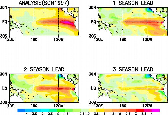
Fig. 4. Observed (left top) and predicted mean sea surface temperature anomalies for September, October and November 1997. The predictions started from July (right top), April (left bottom), and January (right bottom) of 1997.


The statistical performance of the model was investigated with 40 runs of one year forecasts initialized from 1986 to 1996. The initial times are spread equally in each season. Figure 5 shows the anomaly correlations and root mean square errors for NINO3 and NINO3.4 (170°W - 120°W, 5°N -5°S). The figure shows that the skill of the model was deteriorated substantially after 1992 (Note that this experiment does not include the event of 1997/98). Similar reduction of the skill in 1990's with NCEP CMP10 was reported by Ji et al (1996). They pointed out that the skill of the persistency was also reduced and that their EOF analysis indicated less contribution of the ENSO mode to the total SST variations in 1990's, and they suggested that this skill reduction should be attributed to natural changes. Our independent experiment showing the similar skill shift supports their suggestion.


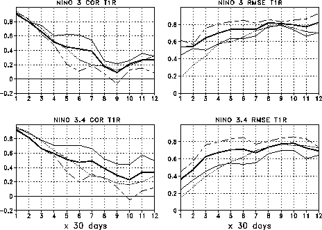
Fig. 5. Anomaly correlation (left) and root mean square error (right, °C) of the mean sea surface temperature over NINO3 (top) and NINO3.4(bottom) for the 40 runs of one-year forecasts with JMA couple model. Thick lines are for all the 40 runs. Solid and dashed thin lines are for the cases from 1986 to 1991 and from 1992 to 1996, repectively. The dotted lines are for the persistence. The abscissa indicates the forecast time in the unit of 30 days, and the value for the mean of the first 30 days of integration and is plotted at 1 in this axis.


In order to investigate the systematic model errors which depend on seasons of prediction period and initial condition, the biases are plotted in the four panels in Fig. 6; for instance, in the upper-left panel, predictions start in the boreal winter (December, January, and February). Predictions starting in boreal winter and spring show large positive biases in July through November. On the other hand, predicted SSTs tend to be cold from December to April when the predictions start in boreal summer and fall.


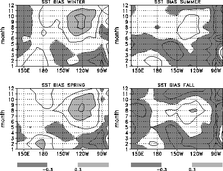
Fig. 6. Season-dependent biases along the equatorial band, 5°S - 5°N. Biases depending on seasons of initial conditions are shown in four panels; boreal winter (December-January-February, upper left), spring (lower left) summer (upper right), and fall (lower right). The contour interval is 0.3°C, and areas where the bias is greater (less) than +0.3°C (-0.3°C) are shaded. The ordinate means calendar months.


These biases may be partly attributed to the inadequacy of the simple flux adjustment applied to the model. They may also be contributed by the deficiency of the ocean model to produce the realistic seasonal variation. When this bias is subtracted, the performance of the model is slightly better, though it should be noted that this is not independent verification.


4. Summary

JMA operates the ocean data assimilation system (ODAS) and it proves to be a useful tool for the monitoring of ENSO. In order to meet the requirements not only for monitoring information but also the future outlook of the El Niño and La Niña events, JMA has developed the coupled ocean and atmosphere model. The model shows the skill slightly better than the persistency. The skill was reduced during the period from 1992 to 1996.

JMA provides the climate monitoring information including charts and indices related to ENSO through the Distributed Data Base of the World Meteorological Organization.


Reference

Ji, M., A. Leetmaa, and V. E. Kousky, 1996: Coupled model predictions of ENSO during the 1980s and 1990s at the National Centers for Environmental Prediction. J. Climate, 9, 3105-3120.

Kimoto, M., I. Yoshikawa, and M. Ishii, 1997: An ocean data assimilation system for climate monitoring. J. Meteor. Soc. Japan, 75, 1-16.

Levitus, S., 1982: Climatological Atlas of the World Ocean. NOAA Prof. Paper No. 13, U.S. Govt. Printing Office, 173pp., 17 fiche.

Louis, J., M. Tiedtke and J. F. Geleyn, 1982: A short history of PBL parameterization at ECMWF, Workshop on Planetary Boundary Layer Parameterization 25-27 Nov. 1981, 59-80.

Mellor, G. L. and T. Yamada, 1974: A hierarchy of turbulence closure models for planetary boundary layers. J. Atmos. Sci., 31, 1791-1806.

Mellor, G. L. and T. Yamada, 1982: Development of a turbulence closure model for geophysical fluid problems. Rev. Geophys. Space Phys., 20, 851-875.


Corresponding author:
Dr. Naoyuki Hasegawa
El Niño Monitoring and Prediction Center
Climate Prediction Division
Japan Meteorological Agency
1-3-4, Otemachi, Chiyoda-ku, Tokyo 100-8122, Japan
Email: naohase@naps.kishou.go.jp