 | Fig. 1. Rainfall records in the urban area of Fukuoka city. |
| Editor's Note: This article is updated from the article presented at the 19th Conference on Severe Local Storms, 14-18 September 1998, Minneapolis, Minnesota (see page 449-452 of the Preprints). The title is changed and two figures are added. For enlarged view of small figures, click on the figures. |
In Japan, particularly in Kyushu Island located in the west side of Japan, heavy precipitation occurs frequently along a stationary front during the rainy season. On the other hand, typhoons also cause heavy precipitation. These cases may be predictable in a relative sense and a preparation for a crucial disaster may be possible because the direct effect of large-scale turbulence leads to a heavy precipitation. However, local heavy precipitation which forms under the effect of local-scale turbulence may be unpredictable because an observational network dense enough to observe and investigate local-scale heavy storms is not developed yet in Japan. From a large number of past studies, a local-scale convergence of moisture under an unstable stratification is considered to a crucial factor for the occurrence and development of a storm system.
Therefore, in this study, our purpose is to investigate roles which local-scale convergence plays for a long-lasting local heavy storm. For the investigation, rainfall data observed during a local heavy storm which occurred in the northern area of Kyushu Island from midnight to early morning on July 28, 1997, are analyzed.
The storm system, which was confirmed in a narrow area, brought heavy precipitation and lasted for more than 6 hours. During this period, rainfall amounts of more than 90 mm/h were recorded at some observational points in Fukuoka city. Further, extremely strong rainfall intensities, over 20 mm in ten minutes, were observed at many places in the southern area of Fukuoka city as shown in (Fig. 1). The heavy precipitation brought urban flood damage including inundation due to internal runoff , at some places in the urban area of Fukuoka city. The occurrence and development of the storm system seemed to be related to the local-scale convergence which occurred around Fukuoka city. In addition, the interesting feature is that the heavy storm occurred, not in the period that the typhoon attacked northern Kyushu, but after the typhoon passed away from northern Kyushu.
| Fig. 1. Rainfall records in the urban area of Fukuoka city. |
The event motivated us to try to investigate why the storm system could retain its power for many hours in spite of its narrow area. But a detailed analysis is impossible because of the absence of Doppler Radar system. Therefore, by turning attention to the wind field near the ground obtained by the below mentioned AMeDAS network, the features of the heavy storm and the roles of the local-scale convergence in the heavy storm system are investigated and discussed.
The observations were carried out in the northern area of Kyushu Island located in the west of Japan (Fig. 2). A part of northern Kyushu is represented by the detailed map (Fig. 3), which has the area of 100km ![]() 100km, centered at the radar site.
100km, centered at the radar site.
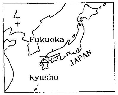 | Fig. 2. Location of Kyushu Island in Japan. |
X band radar is equipped in Kyushu university located at the center of the map shown in (Fig. 3). The radar has a spatial resolution of 1km ![]() 1km with a wavelength of 3.2cm in the relatively narrow area of 100km
1km with a wavelength of 3.2cm in the relatively narrow area of 100km ![]() 100km. The PPI data of the radar is recorded every minute automatically during the duration of precipitation.
100km. The PPI data of the radar is recorded every minute automatically during the duration of precipitation.
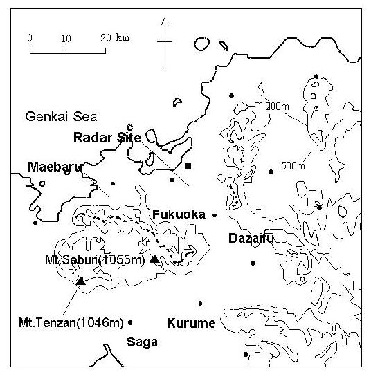 | Fig. 3. Detailed map of Northern Kyushu. |
In order to understand meteorological conditions near the ground, the Automated Meteorological Data Acquisition System (AMeDAS) - the ground observational network of the Japan Meteorological Agency , was used in addition to many rain gages within the Fukuoka district. AMeDAS has the fine resolution of approximately ![]() and consists of four elements, which are wind velocity and direction, temperature, rainfall, duration of sunshine. These data are recorded every hour.
and consists of four elements, which are wind velocity and direction, temperature, rainfall, duration of sunshine. These data are recorded every hour.
In order to understand the influence of the large scale turbulence to the local heavy storm, another analysis of the heavy precipitation was performed using initial data of the numerical model (RSM : Regional Spectrum Model) which the Japan Meteorological Agency uses for daily routine weather prediction .
In this section, some interesting features are presented, based on the above-mentioned observational data of the heavy storm system which occurred locally in the northern area of Kyushu Island from midnight to early morning on July 28 ,1997.
From some satellite pictures of clouds in Asia region, since the typhoon moving far away from north Kyushu was located in the Japan Sea and became enough weak not to confirm the center area of the typhoon, it may be considered that the direct effect of the typhoon on Northern Kyushu was relatively small. From the wind field behavior of the numerical output (Fig. 4) on the ground at 2100 JST on July 27, 1997, the convergence zone of moisture was confirmed to be located in northern Kyushu. It is supposed that the convergence was formed between the wind from the west ant the wind from the northwest that originated from the typhoon. Further, the lower atmosphere over northern Kyushu was convectively unstable up to approximately 1.6 km altitude, from an analysis of atmospheric stability.
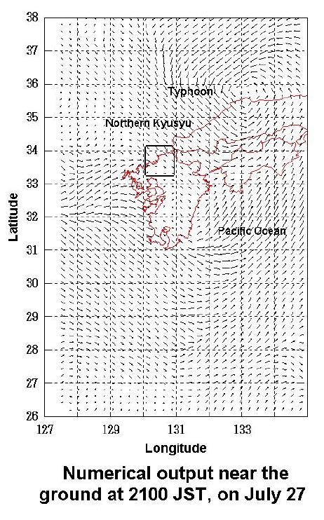 | Fig. 4. Numerical output near the ground at 2100 JST, on July 27. |
Therefore, it is supposed that the atmosphere had potential of high precipitation by the confirmed convergence somewhere in northern Kyushu. But, since the altitude of cloud top was 6.4km and the temperature was -7.4 degrees, from thermodynamical analysis (Fig. 5), further intrusion of cold air into the upper layer was required to develop the storm system. But, evidence of cold air intrusion could not be confirmed because of lack of data.
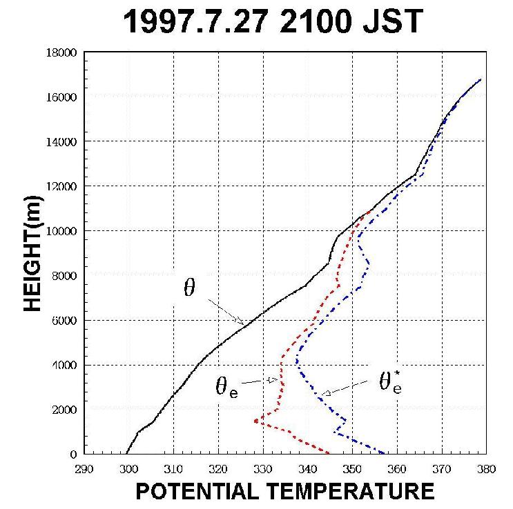 | Fig. 5. Potential temperature calculated from sounding data, 2100JST, on July 27. |
From the wind data of AMeDAS, intrusion of warm air from the south or the southwest was dominant in the southwest part of northern Kyushu from 2000 JST on July 27 until 0000 JST on July 28. On the other hand, The wind feature in the northeast part of northern Kyushu showed the northern wind associated weakly with the typhoon around 2000 JST and no wind or weak wind after 2100 JST. Therefore, it may be supposed that the warm air converged on a line connecting Fukuoka and Dazaifu. In fact, a radar echo appeared around the convergence zone as expected from the wind data as shown in (Fig. 6 and 7, 8). This means that the formation of the convergence zone resulted in the occurrence of radar echo.
From the above results, it may be concluded that the convergence of moisture preceded the onset of the first echo. This fact seems to be consistent with some results of Stanley and Michael (1978). Some of their observations show that convergence precedes the first echo and changes drastically after the first echo. These findings may be useful for the prediction of local-scale storms. In other words, the network of AMeDAS may be available for the prediction. For evaluating this possibility, further exploration will be needed.
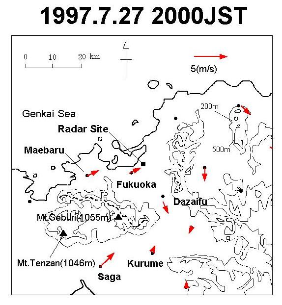 | Fig. 6. Spatial wind at 2000 JST, on July 27. |
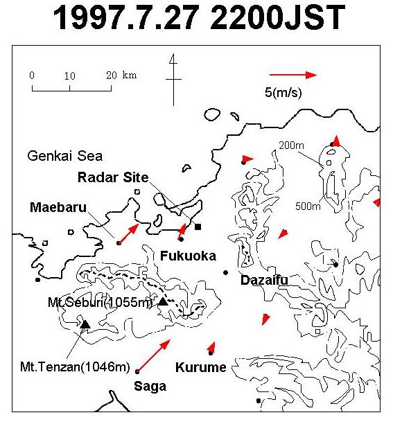 | Fig. 7. Spatial wind at 2200 JST, on July 27. |
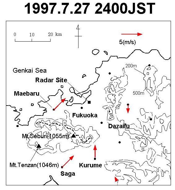 | Fig. 8. Spatial wind at 2400 JST, on July 27. |
The first echo of the storm system was confirmed around 0000 JST on July 28, above the sea of the northwest part of northern Kyushu. This fact seems to be consistent with the result of the numerical output. After the onset of the first echo, several echo cells occurred separately, located in the line between the northwest and the southeast. The cells joined into one storm system, being organized like a band shape as shown in (Fig. 9 and 10, 11). The behavior seems to belong to the type of ``Broken Line'' of four cloud shape types categorized by Bluestein and Jain (1985).
 | Fig. 9. Radar echo distribution at 0050 JST, on July 28. |
 | Fig. 10. Radar echo distribution at 0100 JST, on July 28. |
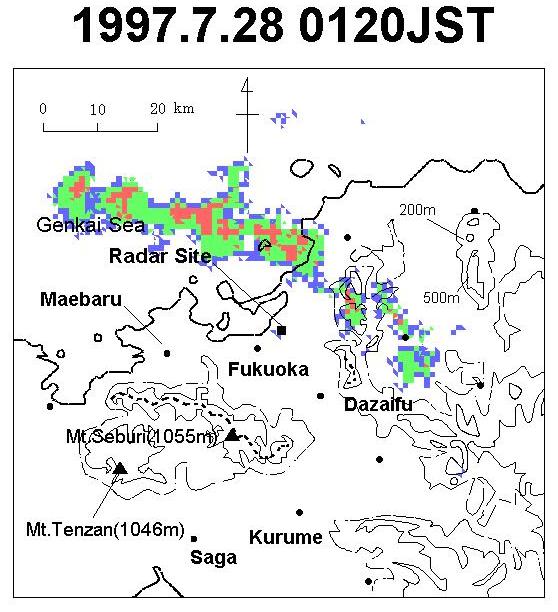 | Fig. 11. Radar echo distribution at 0120 JST, on July 28. |
The most notable feature of the storm system is that the lifetime exceeded 6 hour. One of the reasons may be that the intrusion of warm air from the south or the southwest continued until approximately 0400 JST after the detection of the first echo.
From 0400 JST until 0500 JST, rainfall amounts of more than 90 mm/h were observed at some observational points in Fukuoka. In addition, extremely strong rainfall intensities, over 20 mm in ten minutes, were observed at many places in the southern area of Fukuoka city. But, at that time, the radar echo became weak and the features of the storm system could not be confirmed because of the attenuation of the radar.
The results are summarized as follows ;
Stanley, L.. U., and G. Michael, 1978 : The role of surface divergence and vorticity in the life cycle of convective rainfall. Part I: Observation and analysis. J. Atmos. Sci., 35, 1047-1062.