H. Eito*, M. Yoshizaki, T. Kato, K. Saito and Y. Mano
Meteorological Research Institute
Japan Meteorological Agency
1. Introduction
In winter continental cold air mass sometimes flows out over a warmer sea and a great amount of heat and water vapor are supplied. As a consequence of this air-mass transformation, a maritime mixed layer develops and stratocumulus is generated in its upper layer. In the Japanese Cloud and Climate Study (JACCS), aircraft observations of cloud properties and radiation have been performed for lower clouds around Japan Islands during FY1996-FY1997 winter seasons. The FY1996 experiment has been carried out for marine stratocumulus in the cloud streets west of Kyushu in January 1997. In this study, we tried to reproduce observed features of stratocumulus by using a 3-D non-hydrostatic model and investigated the heat balance in the mixed layer.
2. Numerical Models
The elastic version of the Meteorological Research Institute non-hydrostatic model (MRI-NHM: Ikawa and Saito 1991; Saito and Kato 1996) with the horizontal grid size of 2km was used. The computation domain includes 122x122x38 grids.
The cloud-physics in the model contains the cold rain scheme. In this study, an atmospheric radiation scheme was newly introduced in the MRI-NHM.
In this scheme, radiation in clouds is directly calculated
from liquid water content (LWC) and ice water content (IWC).
The initial and boundary conditions for the MRI-NHM are provided from
output produced by Regional Spectral Model (RSM),
which is a hydrostatic model used operationally
in the Japan Meteorological Agency.
The MRI-NHM is one-way nested within the RSM forecast
whose initial time was 2100 JST on 21 January 1997. The 9-hr forecast of RSM
(valid at 0600 JST on 22 January 1997) is used as the initial condition of MRI-NHM.
3. Results
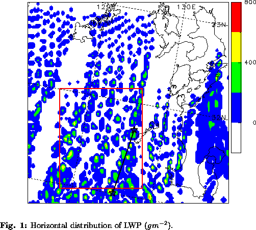
Figure 1 shows the horizontal map of LWP (liquid water path) simulated by
the MRI-NHM at 1230 JST on 22 January 1997 (6.5 hr forcast).
Several cloud streets are obtained and roughly correspond with observations.
They are about 10 km wide and elongate north and south.
Compared with observations,vertical distribution and
the magnitude of LWC simulated by the MRI-NHM are similar.
We investigate the vertical profiles of the components
of heating rate averaged in the box on Fig. 1.
The heating is seen in the whole layer.
In the subcloud layer the heating due to convergence of the upward sensible heat flux is dominant.
In the lower part of the cloud layer
the sum of the heating due to the convergence of the upward sensible heat flux,
condensation and radiation is dominant.
In the upper part of the cloud layer
the sum of the cooling due to the divergence of the upward sensible heat flux,
evaporation and radiation is almost balanced
by the heating due to large-scale advection.
Above the cloud the heating due to large-scale advection
is dominant. It is noticed that the
radiative heating and cooling is not small compared with other terms.
4. Summary
By using the 3-D MRI non-hydrostatic model nested in the operational regional model, observed features of marine stratocumulus and cloud street were well reproduced. The heat balance in the maritime mixed layer was also investigated and shows that the contribution of radiative process is not small compared with other processes.
5. References
*Corresponding author address:
Dr. H. Eito
Meteorological Research Institute
Japan Meteorological Agency
Nagamine, Tsukuba, Ibaraki 305-0052, Japan
E-mail:heito@mri-jma.go.jp