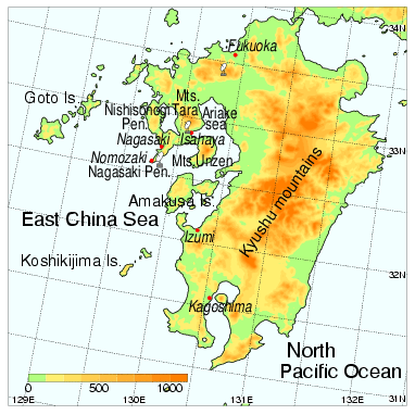
Fig. 1: Map of Kyushu.
T. Kato*, M. Yoshizaki and X-BAIU98 Observation Group
Meteorological Research Institute
Japan Meteorological Agency
1. Introduction
In Japan, torrential rainfalls are often observed in the rainy season (called as Baiu season in Japan), during early June to middle July. Most of mesoscale convective systems have a line-shaped structure and stay at almost the same place for several hours, so that heavy rainfall occurs in their downstream area. The formation of a line-shaped rainfall could be caused from the following causes; the cold pool produced by the cooling effect of raindrop evaporation (Fovell and Ogura 1988), the mountainous barrier effect (Watanabe and Ogura 1987), or the quasi-stationary convergence line and upper-level strong winds (Kato 1998). In the present study, the formation of the line-shaped rainfall observed over the northern Kyushu, Japan (see Fig. 1) on 26 June 1998 is examined by using the observations of RHI and Doppler radar, and the simulation results of MRI-nonhydrostatic mesoscale model (Saito and Kato 1996, MRI-NHM).
2. Observations
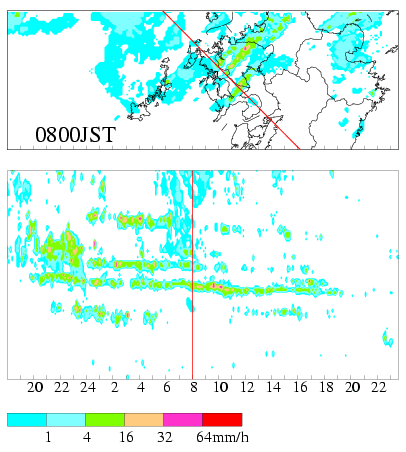
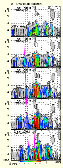
Synoptic overview shows that the Baiu front stayed over the southern Korea. Over the region where strong southeasterly winds predominate south of the front below the height of 5 km, several line-shaped rainbands were observed toward the northwest (Fig. 2a). Especially one of them extending from the Nagasaki peninsula, which is called 'Nagasaki line', lasted for over ten hours. During the period when the Nagasaki line was observed, no developed mesoscale convective system passed over the northern Kyushu (Fig. 2b). Radar analysis revealed that convective cells in the rainband moved toward the northwest at the speed of about 15 m s-1 while developing to the height of over 5 km.
3. Simulation results
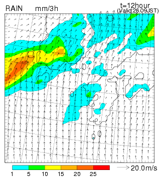
The Regional Spectral Model (RSM, horizontal resolution; 20 km), the operational regional model of JMA, predicts moderate precipitation areas associated with the Baiu front on the southern side of Korean Peninsula and a weak precipitation area on western Kyushu. The latter precipitation area roughly coincided with the observation, but its precipitation intensity was very weak because of coarse resolution (Fig. 3).
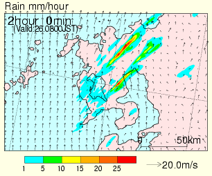
The characteristic features of the Nagasaki line are reproduced successfully by the 1 km-resolution MRI-NHM (Fig. 4). This rainband occurred under the circumstance that relatively cold and dry (low equivalence potential temperature) air flowed into the layer between 2 km and 5 km and the winds veered from the south to the southwest with height. Model-simulated convective cells formed and developed around Nagasaki Peninsula, moving to the northeast (Fig. 5). They were 4-5km in horizontal scale and about 40 min in duration, and propagated at the speed of about 13 m s-1. This result agrees well with the observation. The additional experiment that removes the terrain around the Nagasaki peninsula (the highest mountain is about 500 m) cannot simulate the Nagasaki line, but the other rainbands. The other experiment that leaves only the terrain around the Nagasaki peninsula well simulated only the Nagasaki line. These results show that the mountainous barrier easily rises a near-surface humid air to the free convection level, convective cells are moved by the strong southwesterly winds, and then a line-shaped convective system is produced.
4. Conclusion
Significant factors for the development of a line-shaped rainfall is summarize below. Winds with strong vertical shear veer from south to southwest with height, the atmosphere is nearly saturated in the low-level, the weak mesoscale wind convergence region exists, and the terrain lies in a SW-NE direction.
5. References
*Corresponding author address:
Dr. Teruyuki Kato
Meteorological Research Institute
1-1 Nagamine, Tsukuba, Ibaraki 305-0052, Japan
E-mail: tkato@mri-jma.go.jp