A. Murata*, K. Saito and M. Ueno
Meteorological Research Institute
Japan Meteorological Agency
1. Introduction
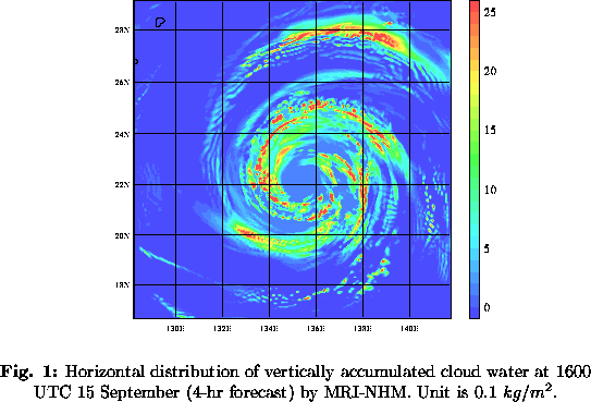
In this study, structures of Typhoon Flo (1990) are explicitly simulated using the Meteorological Research Institute Mesoscale Nonhydrostatic Model (MRI-NHM; Saito and Kato 1999; http://www.mri-jma.go.jp/Dep/fo/mrinpd/INDEXE.htm). Figure 1 shows vertically accumulated cloud water at 1600 UTC 15 September (4-hr forecast) produced by the MRI-NHM with 5-km horizontal resolution. It represents well the common features of tropical cyclones, such as eyewall clouds surrounding an eye. In particular, clouds accompanied by spiral rainbands are well simulated.

2. Numerical model and design of experiments
The MRI-NHM has fully compressible equations with a map factor (Saito 1997) and semi-implicit time integration scheme. It includes cloud microphysics by Ikawa et al. (1991), which predict the mixing ratios of water vapor, cloud water, rain, cloud ice, snow and graupel. Vertical coordinate is terrain following and 38-levels, where the model top is at about 28km. The domain of the MRI-NHM lies just south of Japan (17N-29N, 129E-141E). Initial time of the MRI-NHM forecast is 1200 UTC 15 September.
To investigate how much simulated rainbands of the typhoon depend on precipitaion scheme and horizontal resolution, the following four kinds of numerical experiments are conducted.
The moist convective adjustment scheme used in the present study is proposed by
Gadd and Keers (1970) and is incorporated into the MRI-NHM (Kato and Saito 1995
).
3. Results
In C5, A5, and C20, a rainband to north of the storm center is reproduced. In A20, however, there is no remarkable rainband.
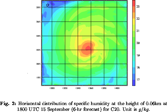
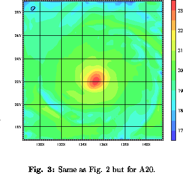
Figure 2 and 3 show horizontal distribution of specific humidity at the height of 0.06 km at 1800 UTC 15 September (6-hr forecast) for C20 and A20, respectively. Experiment C20 has more moisture than A20. The difference between the two experiments in northern sector, where the rainband is located, is larger than that in any other sectors. The less specific humidity in A20, particularly in northern sector, seems to inhibit development of the rainband. Kato (1998) showed that less specific humidity (around 20 g/kg) near the surface produced by the MRI-NHM with the moist convective adjustment, compared with humidity (around 21 g/kg) simulated with cloud microphysics, inhibited formation of rainbands that accompanied with simulated Baiu front (called the Mei-Yu front in China). The present result means that the effect is also applicable in the case of tropical cyclone rainbands.
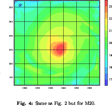
Another forecast experiment (M20) is performed within the framework of moist convective adjustment. The degree of the adjustment becomes weaker in M20 than A20. It is known that moist convective adjustment proposed by Gadd and Keers (1970) makes low-level atmosphere become dry. Therefore, one can expect that drying by moist convective adjustment in the lower troposphere in A20 is suppressed with modification. The horizontal pattern of specific humidity in M20 is similar to that in C20 (Fig. 4). The rainband to the north of the storm center forms in M20 like C20 simulation, whereas it does not in A20 (not shown). The results of the experiment M20 is consistent with the hypothesis that the low-level moisture is one of important factors to control the formation of the rainband.
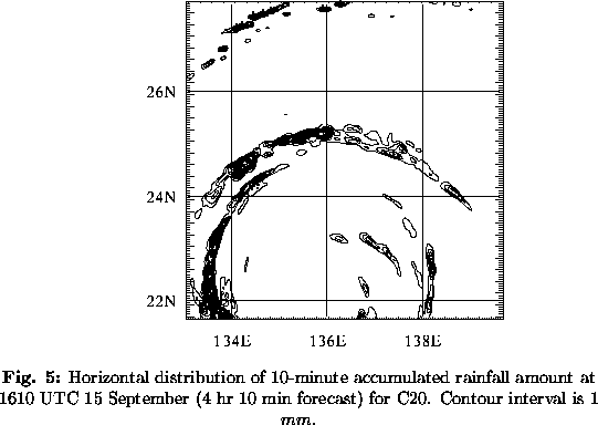
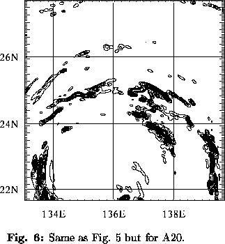
To examine the difference in detailed structure, results of C5 and A5 are compared. Figures 5 and 6 show horizontal distribution of 10-min accumulated rainfall amount at 1610 UTC 15 September (4 hr 10 mim forecast) for C5 and A5, respectively. The rainband of C5 seems to be organized more strongly than that of A5, although both rainbands are shaped like spiral. In C5, there is a cold pool near the surface (not shown), which seems to be brought about by evaporation of raindrop and downdraft. On the other hand, there is no remarkable cold pool in A5. There is a strong updraft zone in C5 (not shown). Its bottom is located on the boundary of the cold pool. Therefore, the updraft seems to be formed by the existence of the cold pool. On the contrary, there is no remarkable updraft zone in A5. The result suggests that formation of a cold pool is one of important factors for the maintenance of the rainband.
4. References
*Corresponding author address:
Dr. Akihiko Murata
Meteorological Research Institute
1-1 Nagamine, Tsukuba, Ibaraki 305-0052, Japan
E-mail: amurata@mri-jma.go.jp