N. Seino* and K. Saito
Meteorological Research Institute
Japan Meteorological Agency
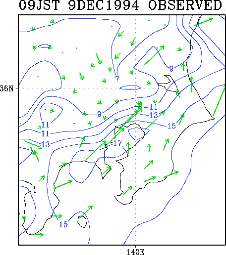
When an extratropical cyclone approaches the Japanese mainland, a locally confined front is sometimes formed along the east coast of the Kanto region, central part of the mainland. The local front causes sharp wind shear along the front and poor visibility in the relatively cold side. Moreover, high air pollution concentrations around Tokyo metropolitan area are often associated with the local front especially in early winter. Basically, the local front is regarded as an interface between the synoptic-scale warm inflow and the cold inland air mainly due to the nocturnal cooling. Some observational studies showed the vertical structure of the front (Yoshikado 1998; Seino 1999). To investigate the formation processes of the local front, a nonhydrostatic model developed at Meteorological Research Institute (MRI-NHM; Saito and Kato 1996; Saito 1997; http://www.mri-jma.go.jp/Dep/fo/mrinpd/INDEXE.htm) was employed.
This study is focused on a local front observed on 9 December 1994. The fully compressible version of MRI-NHM with 32 vertical levels is used. Initial time of MRI-NHM is 0000 JST (Japan Standard Time) on 9 December 1994. Initial and boundary data are taken from the Japan Spectral Model (JSM), which is the operational regional forecast model of the Japan Meteorological Agency at that time with an equivalent horizontal grid interval of about 30 km.
First, the impact of the horizontal resolution was examined using MRI-NHMs with grid sizes of 10 km (52![]() 52 grid points), 7 km (82
52 grid points), 7 km (82![]() 82) and 5 km (114
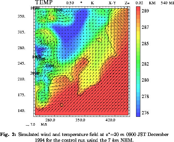
82) and 5 km (114![]() 114). All the models represent that the local front forms and develops by the morning. In the 10 km model, wind shift near the front is less distinct owing to the larger grid spacing. The sharpest wind shift across the front is seen in the finest 5 km resolution model. The temperature contrast across the front, however, is quite similar in the 7 km and the 5 km models. Therefore, it is inferred that the local front is adequately resolved by the 7 km NHM (Figs. 1 and 2). The locations of the surface front forecasted in these models are almost the same and agree with the actual location except in eastern Kanto, where the simulated local front appears far north than observation. Concerning the vertical structure, a stably stratified cold layer with about 500 m depth and the upper southwesterly inflow extending into this layer are reproduced in the inland area.
114). All the models represent that the local front forms and develops by the morning. In the 10 km model, wind shift near the front is less distinct owing to the larger grid spacing. The sharpest wind shift across the front is seen in the finest 5 km resolution model. The temperature contrast across the front, however, is quite similar in the 7 km and the 5 km models. Therefore, it is inferred that the local front is adequately resolved by the 7 km NHM (Figs. 1 and 2). The locations of the surface front forecasted in these models are almost the same and agree with the actual location except in eastern Kanto, where the simulated local front appears far north than observation. Concerning the vertical structure, a stably stratified cold layer with about 500 m depth and the upper southwesterly inflow extending into this layer are reproduced in the inland area.


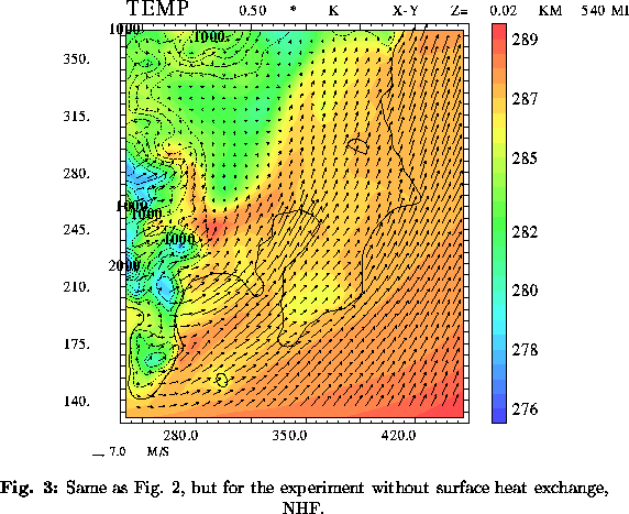
Next, sensitivity experiments were done with the 7 km NHM. In the experiment NHF, the surface heat exchange is removed. The local front is also formed in this experiment, though it moved slightly inland with less frontal temperature concentration compared to the control experiment (Fig. 3). In the other experiment (NZS), the surface flux is neglected and the value of the roughness parameter on the land surface is set to 0.0002 m, the same as on the sea surface. Though stronger wind appears on the land surface in NZS, the structure of the local front is almost similar to that in NHF. These experiments indicate that the effect of differential friction between land and sea is not important. Furthermore, experiments with modified mountain height show that dynamic effect of the western mountain is substantial for the frontal evolution.

Though the research is still on the way, the nonhydrostatic model certainly gives us a new picture of the local front.
References
*Corresponding author address:
Dr. Naoko Seino
Meteorological Research Institute
1-1 Nagamine, Tsukuba, Ibaraki 305-0052, Japan
E-mail: nseino@mri-jma.go.jp