 |
 |
 |
|
|
|
With such good instability and a decent capping inversion (initially),
scattered type thunderstorms rapidly developed during the mid-afternoon
across northwestern Oklahoma. With the isolated nature of the storms, great
instability, and just enough dynamics, things began to get organized. Of
great interest was an isolated severe storm near the intersection of
Kingfisher, Logan, and Garfield counties. Around 5 PM CDT, this storm
exhibited good structure on radar with a well-defined hook echo scraping
ESE across extreme northern Logan county. As the storm moved fairly
slowly across northern Logan county, spotter reports of brief tornado
touchdowns began to come in. Also at the same time, more storms started
firing-up across northwestern Oklahoma.
Even with just a few hours of daylight remaining, we decided to take off.
By the time we left Norman, the first Logan county storm had already
crossed I-35 and was heading into Lincoln County. As it did so, it began
showing classic V-notch and hook echo signatures on radar...this was a
mature supercell! Feeling that trying to catch up to this storm from the
SW would be difficult to accomplish given our remaining daylight, we
decided not to go after the Logan/Lincoln County storm. Instead, we would
try making it to Kingfisher, OK in order to catch any of the other
developing northwestern Oklahoma storms as they moved SE toward us.
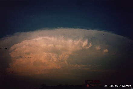
After we got a good distance outside of the OKC metro area, the
Logan/Lincoln storm began to present itself to us. What an awesome
looking storm! Check-out supercell photo
#1 and photo
#2 to see what I mean. The contrast in the pics is not what I had
hoped....but it's good enough to get the general idea across. Though this
storm was not our target, we did get close enough to it to view the
updraft base of the storm. From a distance, we noted a wall cloud and a
possible broken, weak funnel/tornado snaking around and, from time to
time, reaching nearly half-way to the ground. We were too far away to be
sure, though...
Once we reached Guthrie, we decided to take Oklahoma Highway 33 west to
Kingfisher. It was about this time we began to hear reports of a possibly
tornadic storm now moving toward Kingfisher County from the west. Bingo!
Our target storms were organizing. After a while on OK33, we made it just
outside of Kingfisher. As we approached from the east, a large
precipitation core appeared just off to the west. We pulled off the
highway for a few minutes to observe this and snap a few pictures. Just
as the outflow/gust front began knocking on our door, we blazed southward
on a county road. Breaking out of the front-flank mess for just a little
while, we soon became faced with the RFD, which was plowing toward us from
the west. As the RFD passed, winds increased dramatically and were
probably gusting on the order of 60 MPH at our spot just southeast of
Kingfisher. We continued to race south and east to try getting a good
view of the storm's RFB/updraft. After a few minutes, we found a good
viewing spot. Pulling off the side of the road, we noted a large area of
blowing dust to our east...above which there was an angry mess of
low-hanging clouds darting around in seemingly every possible direction.
Every once in a while the spin would tighten up and produce well defined,
localized "eddy" type rotations. Several ragged looking funnel-type
clouds did appear every now and then.
Just as all this started happening, the worst possible thing happened...I
ran out of film! Thinking I was carrying at least 2 spare roles of good
ol' Kodak Royal Gold...I had been content with snapping away at anything
that interested me in the slightest. Well, little did I know there was no
spare film... Doh! So, just as the good stuff got going, I was unable to
photograph anything... At that point, knowing my luck with Murphy's Law, I
figured that all hell was going to break loose. Unfortunately...that
didn't happen. ;)
As the storm continued to slide off to the east, we began to follow it
back to Norman...just as night was beginning to set in. The storm
produced a nice light show north of the northeast side of OKC as downed
powerlines were arcing green, red, blue, and yellow in the distance. This
probably coinsided with the Harrah downburst (a later survey by NWS Norman
described straight-line winds on the order of 100 mph with that event).
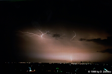
After getting back into Norman, we viewed radar and saw that the storms
had congealed into a nice squall line...which was taking dead aim at us.
Strong straight-line winds were the main concern at this point. Tinker
AFB, I believe, recorded a wind gust in excess of 70 MPH as the squall
passed though. After it plowed through Norman, I took my first lightning
pics as lightning continued spitting out the rear of the storms. See
lightning photo
#1.
All-in-all, it was a fun chase...considering the unexpected nature of
it. I did learn the lesson, though, that in the world of storm chasing,
there are never enough spare rolls of film!
Go back to
the chase page...
Go home...