 |
 |
|
|

|
The question that presented itself at this time was, do we cut-out on an obviously impressive storm to
back-track and try getting to whatever was SW of us, or keep going. The longer I thought about it, the
closer we kept getting to the Kay County storm...which, unintentionally, made the decision easier with
time. Kay County it was...even though the nagging second thoughts of going for the "tail-end
Charlie" storms lingered.
Just as we started closing in on the storm from the S on I-35, awesome mammatus began streaming
overhead on the underside of the storm's thick anvil. I snapped this picture while stopped at a
Conoco somewhere between Stillwater and Blackwell... Lightning activity increased dramatically
during this time as well. Then, just a few miles passed the exit to Blackwell, a very menacing
looking precipitation core became visible off just to the north. Continuing to drive toward this
gave me a rather bad feeling...especially considering that we had been hearing reports from NOAA Wx
Radio of hail baseball sized and larger coming out of this storm a county or two back... Also,
continuing to drive into the front-flank core from the south would likely mean that we had overshot
our prime viewing location, by quiet a bit. Given those factors, the U-turn tactic was employed. We
tried several routes in getting to the storm's updraft...but, for some reason, we just couldn't seem
to find it. After, about twenty minutes of shifting around, we finally got into a good position
inside the inflow notch, just SE of the apex of the front-flank and rear-flank downdrafts and the
rain-free updraft.
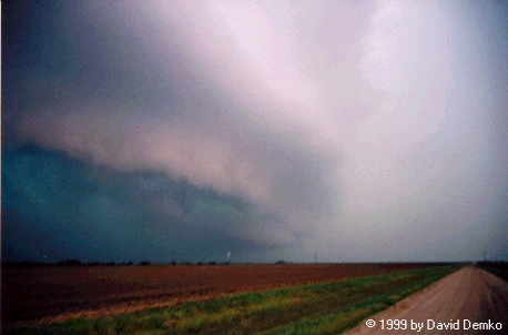
The storm put on a good show. It had very nice "HP" supercell type structure and obvious rotation.
But, by the time we reached the storm, it began to become very much outflow dominated...pretty much
blowing its organization to bits. However, wanting to get something for my
troubles, I hung with the storm way too long...squandering valuable
daylight. It was during this time that we began to get reports of
tornadoes in Kingfisher County. NO! Foiled again!
We drove around outside of Ponca City a bit, got some gas, and then
decided to head back to OU...hopefully returning to OU before the storms
hit Norman (as if storms ever hit Norman...right?!?). The trip home
was quite something indeed... We drove through what seemed to be a solid
line of supercells from near Billings all the way to back Norman. Luckily
for us, we missed most of the hail with these storms. We got stuck in
several blinding downpours, however.
During our trek home, the storm situation became quite interesting near Stillwater. Listening to
reports on KOSU radio, we ascertained that a fairly significant area of rotation must have
been approaching Stillwater from the west. We continued southward and finally broke out of the rain
somewhat SW of Stillwater. With it being dark at the time, we used the extremely intense lightning
as a guide. We stopped off and observed a lowered cloud base to the east-northeast produce a
fair-looking funnel cloud as it moved toward Stillwater.
After that, we continued south. As we approached OKC we began to hear of tornado warnings for Grady
and McClain counties to the SW of the metro. As we entered OKC, a tornado warning went out for
Cleveland County. Yea! Again with chasing tornadoes at night... We continued plowing our way
southward through heavy rain and small hail. Once in Moore, we began to break-out of the
precipitation and saw a very ominous looking cloud base off to the west, illuminated by some of the
most intense lightning I've ever witnessed. We finally arrived back at the dorms around 8:20 PM. We
ran upstairs to our 8th floor TV lounge...which featured a large bay window with a great view to the
north. Between 8:30 and 8:45 we observed a very pronounced lowering/funnel move from west to east
across, what looked to be, the Moore area. Several intense power flashes occurred during this time.
While we were unable to be 100% certain, I bet that what we saw was the Moore tornado in it's
weakening stages...
Otherwise, the storm event ended with a squall line that rolled through
early, EARLY the following morning. The next day, on my way to get pics
developed at our favorite pic stop, the Wal-Green's at N. 12th Street and
Santa Fe in Moore, I some fairly impressive damage brought on by the Moore
tornado. Little did I know, not more than 5 months later, the same area,
including our beloved Wal-Green's, would fall victim to one of the
strongest tornadoes in Oklahoma history (more on that here).
The NWS in Norman has also put together a great summary of this event
with relevant radar images, damage survey results, etc. Click here for that.
Go back to
the chase page...
Go home...