
04.05.05 Tom Bean, TX Squall Line
Storm reports encountered on the chase:
Hail Reports
2230 88 2 NW TOM BEAN GRAYSON TX3354 9651 NICKEL HAIL 2 MILES NORTHWEST OF TOM BEAN RELAYED BY WFO NORMAN (FWD)
Chase Account
Eric Holthaus, Renee Curry and I set out from Norman around 1pm to head south toward our target of Durant, OK. The visiting students from University of Reading: Matt, James and Claire also caravanned with us. The 15z RUC was forecasting initiation just south of this area near the Red River Valley so we anticipated meeting up with it there and heading northeast on Highway 69 the rest of the afternoon.
The strong southwesterlies made driving south down I-35 quite the challenge, but we were in the perfect location to see the growing cumulus field just off to our east as we neared Ardmore, OK. We decided to stop there at 2:05 pm to make a data stop at the Love's TruckStop (the Wifi access works and is FREE!). The first radar image I pulled up showed the first cell of the day popping up just east of us, but myself and Eric felt we should probably go a little further south and wait for something better to initiate later on. So we stayed at Love's for another 15 minutes or so looking at the SPC mesoanalysis page and reading the recent discussion that had come out for eastern OK along the dryline, anticipating a tornado watch in the near future. Around 2:20 pm we were ready to jump back onto I-35 and head a little further south, but decided to check out one more updated radar image. Much to our amazement in the 15 minutes we were there the cap had broken across the entire dryline down to the Red River. This pretty much took the wind out of my sails since the possibility for a discrete cell in OK was virtually eliminated in that 15 minute timespan! I made the decision for us to make the trek into Texas with the slight hope that discrete cells would fire later further south along the dryline, considering how much the DFW weather radio was stressing the tornado potential we felt this decision may save our trip.
Too much shear! Check out those crazy tilted updrafts Across the Red River we go to Texas
Note to others: Don't use Highway 377 to cross the Red River as it is down to one lane and you must wait for like five minutes to take turns to cross. Once into TX we unfortunately continued to see the cumulus begin to tower slightly in a linear formation, so we navigated our way to Highway 82 and headed east to Sherman, crossing our fingers and rubbing four leafed-clovers to convince mother nature to develop a discrete cell out ahead of the dryline. As we headed east we continued to hear Severe Thunderstorm Warnings for the original cells that initiated to the east of Ardmore, but there was also new Warnings coming out further south from around the Dallas metroplex. Once we got past Sherman we were about 25 miles out ahead of the dryline and there were no indications of pre-dryline convection so we made the decision to drop south on Highway 69 and backtrack westward to punch through the squall line to see how much trouble we could get ourselves into.
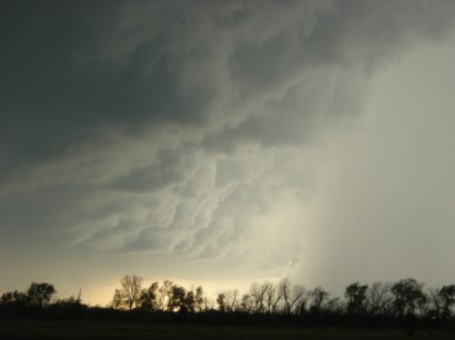
Once into Whitewright, TX we headed northwest on Highway 11 to encounter the squall line near interestingly named Tom Bean, TX. We stopped for a few minutes at a Methodist church to marvel at a beautiful shelf cloud and interesting forward flanking inflow band.

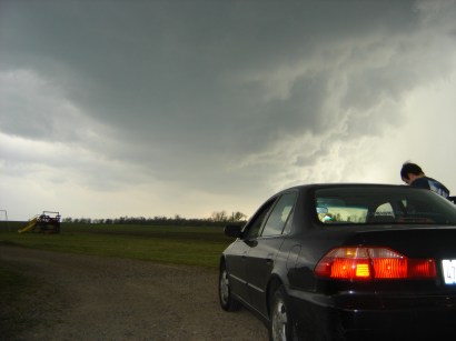
The outflow gusts from the squall line picked up and we jumped back in my car to punch on through it. Just two miles northwest of Tom Bean at 5:02 pm we began to encounter some torrential downpours and pea sized hail so we pulled over to enjoy the show. What ensued was the longest sustained hail storm that I have ever sat through. For the next 15 minutes until 5:17 pm we could hardly hear each other speak as dime and nickel sized hail pelted us. Apparently this doesn't phase TX drivers because plenty of them flew by us on Highway 11...how they could see further than 1 foot in front of their vehicles is a mystery to me during this hail swath.


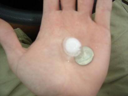
Around 5:17 pm we headed another mile northwest on Highway 11 where we found some nickel sized hail. After 5 minutes of unsuccessfully getting thru to the Ft. Worth WFO, Eric finally called Norman and had them relay the report so that explains why the timestamp on it is later at 22:30 z.
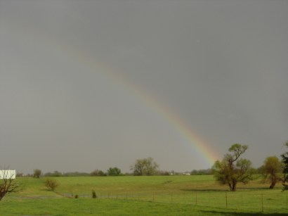
What was most amazing was the slow 15 to 20 mph speed the squall line was progressing at. It dropped impressive amounts of rain during its 20 minute lifespan over locations. We headed back south and took some photos of the flooding at the same church we had been at earlier. A few remaining hailstones from the potent updraft can still be seen in the first two photos. From here we headed back north on Highway 69 and took the obligatory rainbow shot with the advancing squall line in the background.


We then decided to call it a day and head back towards Norman around 6 pm, but first we had to find a nice small town diner to grab some dinner. Driving on Highway 70 through Madill, OK I found the perfect spot: Hobo Joe's Diner. We walked in there and received some of the funniest looks ever from the locals but they were all very nice to us. I would recommend the food too as my marinated chicken breast and fried squash were excellent. Apparently we just missed out on the Wednesday catfish special.
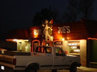
Yes, that really is a cut-out of a hobo that greets you at the door
The lesson of the day was to realize the it is nearly impossible to form discrete cells with 30 knot flow at the surface and 55 to 60 knot flow at 500 mb shearing your storms apart. Most of the day we were under some of the most sheared out anvils I have ever witnessed. They extended 40 to 50 miles from the convection and were not the result of overshooting tops. Now the attention turns to this weekend's possibilities, although after today I will be pessimistic of the upcoming April systems.
©2005 Nic Wilson